

I always dreamt of climbing mountains while growing up. Into Thin Air was my favorite book growing up and I poured over photos and stories in the pages of National Geographic of these adventurous climbers summiting iconic peaks around the world. I wanted to be like them.
Much of my life has been spent in the mountains; skiing in the winter, hiking and camping in the summers. However, I mainly admired the peaks from below, rather than attempting to reach the top of them–those that required technical gear and experience at least. It wasn’t until I began to feel the need to challenge myself more that I decided to take up mountaineering.
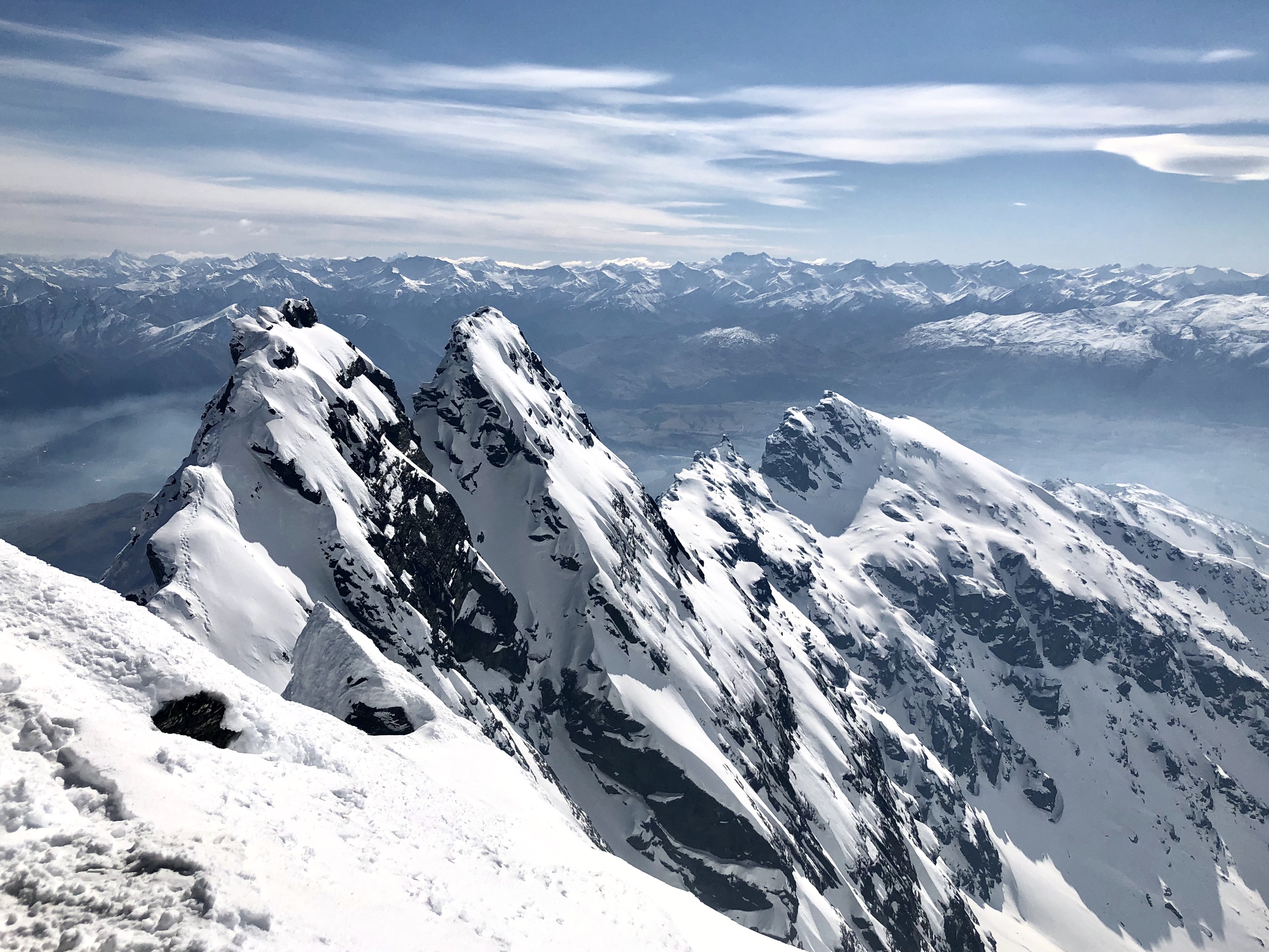
The Remarkables Range, just over half an hour from Queenstown, offers some of the most accessible climbing and mountaineering in New Zealand. This makes it an ideal location for beginner climbers to get their ‘feet wet’ in mountaineering and be able to bag a couple impressive peaks, all while making it home in time for dinner and après.
Our plan was to climb and ski Single Cone, the highest peak in the Remarkables, dominating the skyline over Lake Alta and the ski resort below. For my partners and I, this would be the first of several ski mountaineering missions in an effort to eventually summit and ski the iconic Mt. Aspiring at the end of the season. Considering this was my first time using an ice axe and crampons, I would need a few more of these ‘warm-ups’ before that attempt happened.
Luckily, I had two experienced and trustworthy partners, both of whom I met in Queenstown while working at a local ski shop over the winter. Kaz is an early-30’s and unbelievably fit Japanese fellow who moved to New Zealand over five years ago. He spends his winters ski instructing in Queenstown and his summers guiding multi-day hikes on the famous Milford and Routeburn Tracks. Julen is a Spaniard just a couple years younger than me and my main ski touring partner of the season. He is one of those who enjoys the uphill even more than the downhill. In recent years I’ve come to enjoy the uphill more (or rather, hate it less), but skiing for me is still about about the deep turns and high-speed descents. But who knows, maybe this whole climbing mountains thing will give me new perspective.
We could not have picked a better day to summit. The morning started out a touch overcast, but by the time we left the ski area and put skins on, only a few lingering clouds remained in an otherwise clear sky. The route was straight forward, skinning from the top of the chairlift and then ascending up the southwest ridge of Single Cone. Crampons were not needed until just below the summit, where a short, but steep and VERY exposed, section was our only obstacle before reaching the top. Luckily, the snow was in perfect condition for climbing-soft enough to punch through with crampons, but firm enough to feel stable. I tried not to think about the fact that I had 3000 feet of vertical drop between me and the ground below, with no rope to catch me if I did slip.

However, the exposed section was short and not too technical and it wasn’t long before we were taking in the views from the top, looking across at Double Cone and the other Remarkables peaks, and down to Lake Wakatipu and Queenstown below. Two ski patrollers were also at the summit–with mono-skis on their packs–who were planning to summit and drop into the Grand Couloir on the other side during their lunch break (crazy cats).

We descended the same way we came up and had a cruisy ski down to the bottom as the morning breakable crust had softened up into a fast and carve-able cream cheese. By the end of the day, I was wrecked but felt much more confident in my mountaineering skills and ready for the next mission.
About the Route
New Zealand may be the ultimate road trip destination. One of the most spectacular–and least visited–road trips follows the Pacific Coast of the deep south, to the very southern point of the South Island, and back up through New Zealand’s famous southern alps and fiordlands. Towards the end of the southern hemisphere autumn, I hopped in my van and set my sights south, taking in the spirit of this historically, culturally, and ecologically rich region.
Oamaru
The Southern Scenic Route officially starts in Dunedin, but I wanted to include the coastal town of Oamaru, just an hour north, which turned out to be one of my favorite stops along the way. Famous for its 19th-Century Victorian limestone architecture, dramatic coastlines and abundance of wildlife, Oamaru is a can’t-miss destination for visitors to the South Island.
After checking in to my room at the quaint and homely local YHA, I made my way on foot to the Victorian Precinct, a small historical district comprising of a couple streets sandwiched between downtown and the harbor. Walking through the narrow streets lined with grand old buildings on either side and penny-farthings leaning against alleyways, transported me back to an earlier time. The buildings are constructed with limestone sourced from local deposits and house a variety of odd and curious shops that maintain the Victorian aesthetic. I spent my time browsing through the impressive collection at Adventure Books, home to rare editions of prints detailing early Himalayan and Antarctic explorations, as well as limited copies of Captain James Cook’s own personal sea journals. Next door, a local stonemason and artist was creating intricate and delicate sculptures from blocks of limestone.

Fitting to the Victorian theme, Oamaru is also regarded as New Zealand’s ‘steampunk capital.’ The Sci-fi genre popularized in the works of authors such as Jules Verne and H.G. Wells, steampunk is characterized by a cross between the steam engines and fashion of the British Victorian-era and futuristic fantasy worlds exploring ideas like time travel and robotic machinery. Oamaru’s Steampunk HQ is an interactive museum portraying steampunk-themed art and constructions created by New Zealand artists. Walking around the dark, eerie museum, surrounded by displays of gothic trains and submarines, and machines promising to transport me to a far away time and world, I felt as if I had stepped straight onto the set of Mad Max.
Before leaving Oamaru, don’t miss the opportunity to gorge on some mouthwatering cheese rolls–a Southland delicacy–at the Whitestone Cheese Factory.

On my second day in Oamaru, I took a day trip to the Moeraki boulders. These odd, perfectly symmetrical boulders are strewn across the long stretch of beach like golf balls clubbed by some giant with a 7-iron from miles away. They were, in fact, formed over millions of years on the sea floor as great pressure consolidated the sediment together, until the coast uplifted from the sea and the cliffs eroded away, allowing the boulders to roll free onto the beach, where they lie today. Along with these geological wonders, Moeraki provides quiet, wide stretches of sand perfect for a long early morning beach stroll.

Dunedin
The port city of Dunedin has a significant history of whaling, gold, and Scottish immigration. During the height of the central Otago gold rush, Dunedin–the closest port–was the most populated and wealthiest city in New Zealand. Today, it is known as a buzzing college town with a vibrant arts, music, and cultural scene, as well as being located next to, and within, habitats for some of the world’s rarest and most unique wildlife.
The Elm Wildlife Tour is not to be missed while in Dunedin. The half-day tour brings you within close proximity to the world’s largest sea bird–the royal albatross, the world’s rarest penguin–the yellow-eyed penguin, as well as endangered sea lions, and New Zealand fur seals. Elm’s wildlife guides are knowledgable and and will ensure you have an unforgettable experience, one that is safe for both you and the animals.


The Catlins
The Catlins, hidden in the deep bottom corner of the South Island, is one of the few relatively unspoiled places left in New Zealand. Here, native rainforest and old-growth still thrives, growing right up to the wide open beaches, rocky shores, and the vast Pacific Ocean.
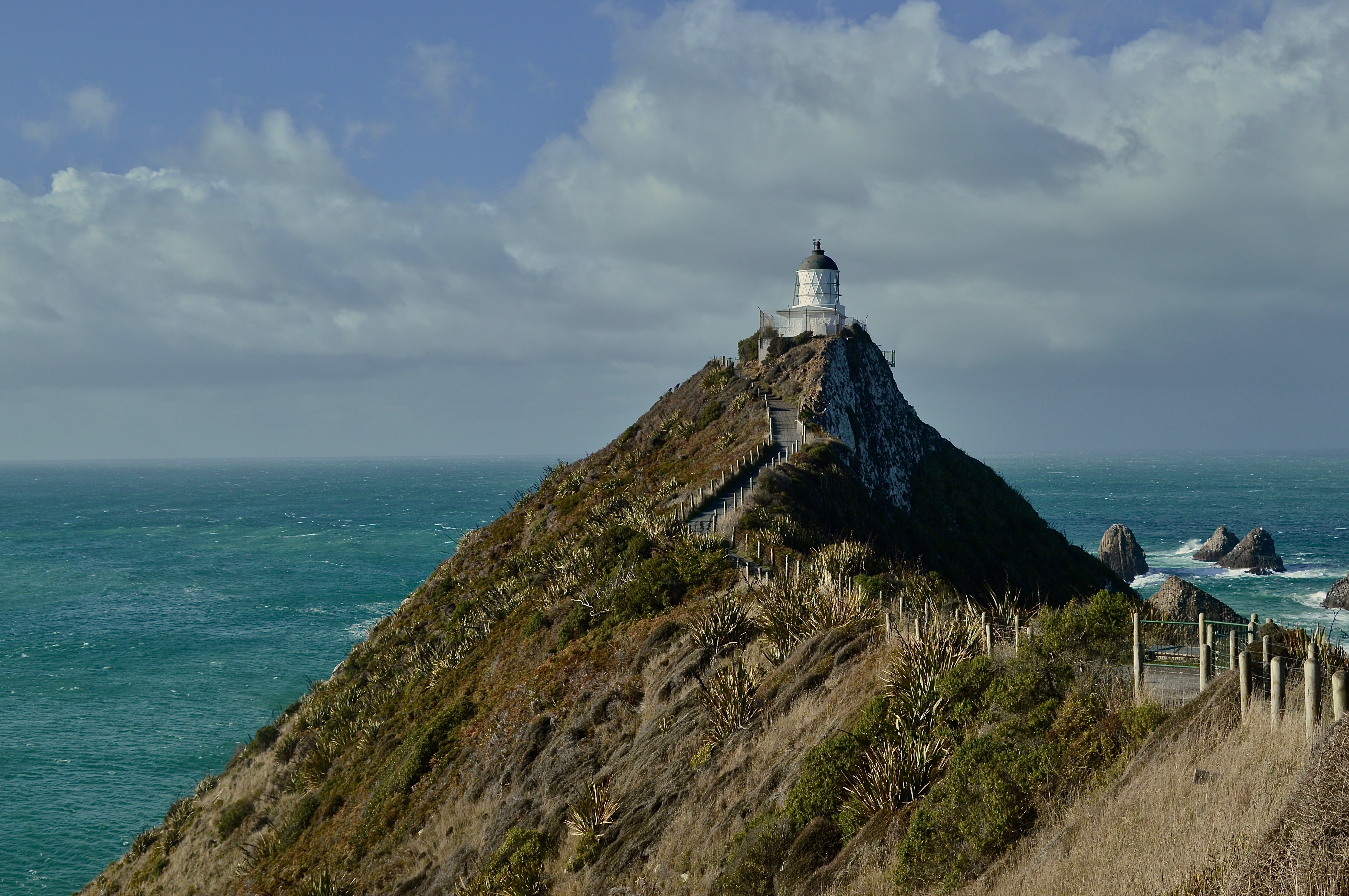
I spent two days driving through this wild and sparsely populated country, staying a night in the small town of Balclutha. Just an hour or so drive from Balclutha, is the Nugget Point lighthouse, a perfectly picturesque historic lighthouse perched on a steep cliff overlooking the shoreline. A short scenic walk takes you to this outstretched point providing views of the dramatic coastline of The Catlins and the rollicking sea below.
The next day, on my way to Invercargill, I stopped several times along the empty highway, which opened up to some of the most incredible landscapes I’ve ever seen. The highlights included Tautuku Bay, where dense old-growth forest saturated with the sound of birdsong and the pounding surf meets a stunning stretch of sand. In the middle of the forest, lies Lake Wilkie, home to a small teardrop lake with mirror-like reflections and a unique brackish habitat.
Further south along the road lies Curio Bay, where more serene coastlines, beaches, and wildlife habitat await. The rain and wind came and went all day, drenching down onto my van as I drove along one moment, and clearing up the next, revealing a new and wondrous sight with each sweep of the wiper blades.
By the time I reached Curio Bay, the downpour was relentless and the wind threatened to blow me off to sea as I climbed a hill to the top of a cliff overlooking the bay. A sense of overwhelming joy and laughter overcame me as I stood there, bracing myself against the onslaught of bullets cascading down from above. It was miserable, yet perfect.


Invercargill/Bluff
Invercargill is the southernmost major city in New Zealand, and one of the most southern cities in the world. The main reason I went here was to visit Bluff–the southernmost town in New Zealand and gateway to Stewart Island.
Bluff is famous for primarily two things: first, the ‘Edge of the World’ signpost displaying the distance to various destinations around the world and second, the oysters. Bluff oysters are sold all around New Zealand but I wanted the full experience of visiting Bluff during oyster season (March-August) to try out this delicacy.
Hailing from the Pacific Northwest, I am no stranger to good fresh oysters, but I will say these Bluff oysters were at least equal too, or maybe even surpassing the ones of my home country. The first place I stopped was at a small take-way shop along the side of the highway heading into Bluff called Fowler’s Oysters. This is one of the most popular places to sample oysters in Bluff, serving them in almost every way imaginable. I tried a half dozen fried with a serving of chips and a piece of fried Blue Cod on the side. Light and crispy on the outside and warm and tender on the inside, this savory comfort meal hit the spot after braving the rain and cold winds all day at the edge of New Zealand.
If you are really keen on getting your oyster fix, as I was, there are much more dining options in Invercargill. For dinner, I stopped in to The Rocks cafe and restaurant where I ordered another half dozen Bluff oysters, this time raw with a splash of lemon and malt vinegar–the real way to eat fresh oysters. Shooting them like tequila shots, I finished the plate in about 30 seconds, satisfied yet still contemplating placing another order.
Aside from splurging on fresh oysters, Invercargill and Bluff are also home to a number of fascinating museums including the Bill Richardson Transport World car museum and the Bluff Maritime Museum–a small exhibit displaying the history of exploration, whaling, shipping, and oyster harvesting in the Bluff region.


Te Anau
The last stop along the Southern Scenic Route before driving back to Queenstown is Te Anau, located along the shore of the massive Lake Te Anau. This small town is the gateway to Fiordland National Park and also a starting point for the Routeburn, Kepler, and Milford Tracks–three of New Zealand most famous Great Walks.
Along with these popular tracks, Te Anau offers a seemingly endless array of outdoor opportunities including day hikes, mountain biking, fly fishing, and scenic flights and helicopter rides. The town is also only a couple hour drive from Milford Sound, along what might be one of the most scenic and breathtaking highways in the world.
Upon completing the Southern Scenic Route, you will have visited three different seas–the Pacific Ocean to the east, the Southern Sea to the south in Bluff, and the Tasman Sea to the west at Milford Sound. Hopefully you were also lucky enough, as I was, to see some of the world’s rarest wildlife, most unique landscapes, sample some truly delicious local Southland cuisine, and experience a region rich with history and culture.

“Before them stood the mountains of the South: white-tipped and streaked with black. The grass-lands rolled against the hills that clustered at their feet, and flowed up into many valleys still dim and dark, untouched by the light of dawn, winding their way into the heart of the great mountains. Immediately before the travellers the widest of these glens opened like a long gulf among the hills. Far inward they glimpsed a tumbled mountain-mass with one tall peak; at the mouth of the vale there stood like a sentinel a lonely height. About its feet there flowed, as a thread of silver, the stream that issued from the dale; upon its brow they caught, still far away, a glint of the rising sun, a glimmer of gold.”
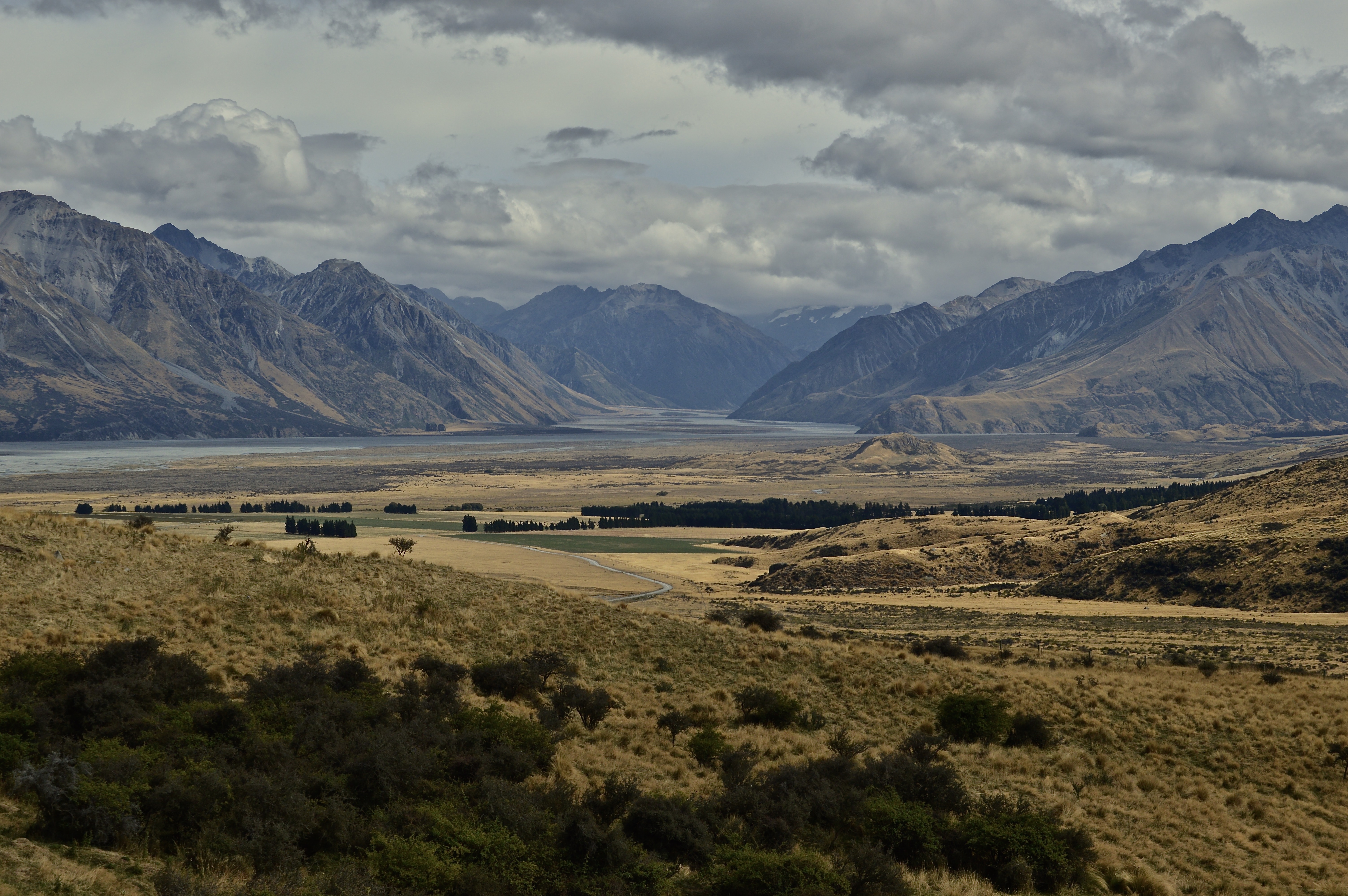
This is Tolkien’s first description of Edoras–the capital city of Rohan–in The Lord of the Rings. When crews were sent out to scout film locations for the trilogy, this is what they were looking for–grasslands, great mountains, a lonely peak, a silver stream. They spent several months searching until finally they found it, deep in the heart of the South Island, the perfect location; it was as if Tolkien was actually describing the landscape of New Zealand, rather than that of Middle Earth.
Here is the view they came across. Welcome to Rohan:

The city of Edoras itself was located on the small rocky hill at the base of the mountains, on the middle-right portion of the photo. This hill, while not really a mountain, is named Mt. Sunday and right in the center of one of the largest and most remote sheep and cattle farms in New Zealand. The location is quite difficult to access as it requires a long drive on a gravel road deep into the highlands of the South Island. It takes about two-and-half hours from Christchurch and one-and-a-half hours from Methven. Luckily for us LOTR nerds, a tour to Mt. Sunday is provided by Hassle Free Tours that picks up at either Christchurch or Methven.
The all-inclusive tour includes transportation to Mt. Sunday, lunch, behind-the-scenes photos and videos of the filming of Edoras, and a quiver of props from the movie for some epic photo opportunities.
I was the last to be picked up, in Methven, and joined about ten others on the bus who all left from Christchurch. Our little Fellowship was led by our driver and tour guide, Chris, who provided informative and entertaining commentary on the filming of the movies and New Zealand’s natural history. Along the way, we made several quick stops at viewpoints that provided remarkable scenery of the vast and open highlands landscape.

I was expecting Mt. Sunday to be packed with tourists attempting to recreate movie scenes for their Instagram shots, but to my surprise, aside from our group, we only came across four other people the entire time we were there. Again, it is difficult to get to and not quite as well-known as other film locations like Hobbiton on the North Island. Thus, I was able to recreate film scenes for my own Instagram shots in peace.

From the car park, it is a short but fairly steep walk up to the top. Of course, the constructions from the movie set are no longer there. A part of me feels that it is a shame that the incredibly detailed and intricate buildings of Edoras were taken down just days after they were built, including the great Golden Hall, where the king sat, but the other part applauds the film crew for leaving this wild and pristine landscape untouched. Despite housing the crew and actors, and hundreds of extras, as well as serving as a construction site for a fake city, there is no evidence that anyone was ever there. Even the jeep track that was used to carry the actors and equipment to the top was covered up.
We had no jeep available, so we had to hike up. Breathing heavily and starting to break a sweat, I arrived at the top and took my first look over the expanse of Rohan. A strong gust hit me head on, tunneling through the deep, mountainous valley ahead. No sign of the mighty Rohirrim galloping over the plains could be spotted, but the vista before me felt as epic and magical as Middle-Earth nonetheless. We carried up props that included King Theoden, Frodo, and Aragorn’s swords, and the banner of Rohan for the perfect photo opportunities.


After around a half hour at the top, we hiked back down and headed to Mt. Potts lodge, just 5 minutes up the road from Mt. Sunday, to enjoy a lunch of sandwiches and New Zealand sparkling wine while taking in the mountainous views one last time. From there, we made the drive back, leaving Edoras and Middle Earth behind us.
Hassle Free Tours has a monopoly on the Mt. Sunday tour, so the price is a bit steep, but take a look on Bookme to find deals (I scored my tour for half price!). Of course, if you have a car, you can drive to Mt. Sunday yourself and enjoy it for free! There’s a good chance you will have it all to yourself as well. However, your photos won’t include any swords or flags and, thus, lose about half the potential epic-ness.
For die-hard LOTR fans, or for those those looking for a scenic day trip in a remote and wild location, Mt. Sunday is well worth the trip.
Forth Eorlingas!
Here is a little update on my life at the moment:
After 6+ months of travel across two continents and 11 countries, I am now, more or less, settled down in the third and 12th–New Zealand. This small and scenic country in the far corner of the globe will be my home for the next year, where I will be traveling around and working on a Working Holiday Visa.
It’s been over half a year since I left home last August, and it has truly been quite the epic journey for me. From hiking around the European Alps to drinking beer at Oktoberfest in Munich, trekking through the high Himalayas of Nepal and riding camels in the deserts of India, ringing in the New Year with lanterns and fireworks in Chiang Mai, and skiing bottomless powder in Japan, the experiences of the last few months have created memories that will last a lifetime.
Having said that, I am ready to settle down a bit and have a place that feels like home again. I don’t think I will miss the early flights, enduring overnight train rides (no matter how cheap), and not-so-private hostel dorm rooms too much, though they made for plenty of good stories. Perhaps best of all, my bank account will finally be seeing some additions again after constantly dwindling down over the last few income-less months. In other words, I am still traveling, but not quite as the wayward bum I previously was (though still somewhat of a bum).
I arrived in New Zealand a little less than a month ago and have been busy getting myself set up since landing. The first week was spent in Christchurch where I had to do the mundane, but necessary, tasks of setting up a bank account, IRD number, phone plan, and insurance. Oh–and I bought a car! …as well as a whole heap of camping equipment and a mountain bike. So for now, I am all set to explore the wild and scenic landscapes of New Zealand.
But first, I had to find a temporary job as I spent the rest of my money on all these new toys.

Before I left Christchurch, however, I was able to see some old friends from back home–Nathan and Caile–who were on a cruise around New Zealand and docked in the city for a day. Unfortunately, we only had a few hours to spend together, but were able to catch up and make the most of it, highlighted by a scenic gondola ride up to a viewpoint overlooking the city and sea. How crazy it is to run into old friends from home in the other corner of the world!

I found a job on an apple orchard near Cromwell in Otago, where I have been for the last couple weeks. I was able to make a mini road trip out of drive here from Christchurch as I rode some bike trails at Mt. Hutt, visited Mt. Sunday–the filming location for the city of Edoras in the Lord of the Rings films, and took a scenic detour up the highway to Mt. Cook/Aoraki.


The orchard work is difficult, but rewarding, and I have made many new friends as there are about 15 of us here–all backpackers. We work together, cook, together, and party together.
I plan on staying here and working until meeting up with parents, who arrive in just over two weeks. I will travel with them for about a month, before settling down for a winter of working and skiing in Queenstown.
I have been in New Zealand for less than month, but I already have the sense that this is somewhere I could live. All the places I have visited thus far have brought me great enjoyment, but now it feels as if that chapter of my journey is ending, giving way to a new one. One that will surely be full of joy and adventure in this small, yet grand country.
The Bamboo Experience, Laos
On my first day in Luang Prabang, Laos, a fellow traveler at my hostel recommended that I spend a day at “The Bamboo Experience.” Of her weeklong stay in the area, she told me this was her favorite activity she undertook; yes, even more so than the majestic Kuang Si Falls. It was a bit on the pricey side, but I decided to take her advice and booked it.
The Bamboo Experience is a half-day course on all the traditional and local uses of bamboo, taught on a small property outside Luang Prabang. Bamboo is known as the “miracle plant” in Laos, as well as other neighboring Southeast Asian countries, and has been used for thousands of years as the primary material in making homes, tools, art, and even food. Upon arriving, I immediately noticed several bamboo clumps growing at the edges of the property. I, along with the other guests, were escorted through a quaint vegetable garden lined with bamboo fencing and bamboo benches, and into the main building, which of course, was constructed almost entirely with bamboo.
To begin the day, we were given a brief overview of the bamboo plant and shown several items the people of Laos would typically make from bamboo. This included everything from fish traps, to straws, rice steamers, mats, and musical instruments.

Next, we participated in a bamboo weaving class, where we learned how to weave thin paper-like strips of bamboo into small coffee coasters. The process is similar to knitting a quilt, but with bamboo instead of soft yarn and thread. Weaving was traditional done by Laotian women, who spent hours creating intricate and durable mats, flooring, nets, hats, and a host of other materials. It took a few attempts before I was able to lock the pattern down, but once I finally got it, I moved along with a rhythmic flow, and I must say, the final product didn’t come out too bad!

Following was a cooking class that used bamboo shoots as the main ingredient, accompanied by other traditional Laotian ingredients, which once cooked and prepared, we enjoyed as a delicious and beautifully presented lunch.
To end the day, we were treated to a traditional Hmong song and dance, performed with a large flute-like instrument made from bamboo that produced a sound similar to that of a didgeridoo.


Overall, it was a fun and informative experience that opened up the world of bamboo to my eyes. The people of Laos have used the plant in their daily lives for thousands of years, but what about the rest of the world? Could we all turn to bamboo? I wanted to learn more about this “Miracle Plant” and see if it truly could be a sustainable alternative to timber and a viable solution to the issues of deforestation, habitat loss, soil erosion, and climate change that our world faces today.
Bamboo as a Sustainable Alternative
Where does it grow?
There are over a thousand species of bamboo worldwide, normally growing in tropical or sub-tropical climates in Asia, Africa, and the Americas. Although bamboo species can be found in a range of differing climates, such as the high Himalayas and the cold, snowy winters of northern Japan, in general, bamboo will grow in the humid climates of the middle latitudes.
Characteristics
Bamboo, typically thought of as a tree or hardwood, is actually a type of grass and is one of the fastest growing plants in the world. It will reach maturity, and its maximum height, in a matter of years, or even months. Many trees that are generally felled for timber, in comparison, often take decades to centuries to reach maturity. This means, when bamboo is cut and harvested, it will regrow to the same height and can be harvested again within a couple years. In contrast to trees, bamboo does not need to be replanted, but will continue to regrow again and again after it has been cut. This is a reason many experts believe bamboo can be a sustainable alternative to timber to help alleviate deforestation and pressures on the Earth’s old growth forests.
There are an estimated 1400 different species of bamboo worldwide. With so many differing species, each species of bamboo contains characteristics that make it more suitable for a specific traditional purpose, or use. For example, some species are larger in circumference–suitable for construction of homes and bridges, and some smaller–for items like straws, instruments, or fish hooks. Other species may have long sections between nodes (the rings, or “ends,” that are evenly spaced along a bamboo pole and seem to connect it together), which is perfect for slicing off long strips to be used in weaving, and some will be short and stubby, making the pole much stronger and resistant to snapping under pressure.
David Trujillo, a structural engineer and advocate of replacing steel and concrete with bamboo, details the many benefits of bamboo in his TedTalk on the subject (watch it here). According to Trujillo, the fibers in the wall of bamboo are three times stronger than steel, and with nodes for support and an efficient natural hollow shape, bamboo is lighter and stronger than steel. Perhaps, more importantly, bamboo is also much cheaper than steel, both in terms of monetary costs as well as carbon costs. Where a significant amount of carbon dioxide is released in the production of steel, bamboo stores carbon and is, therefore, carbon neutral, or even carbon negative, in its production and use. Thus, if we began using bamboo instead of steel or concrete, we would not only be producing less carbon, but actually capturing and storing carbon that is already in the atmosphere.
Uses
Each year in Luang Prabang, Laos, at the start of the dry season, when the Nam Khan River at its lowest flow, locals construct a bamboo bridge across the river to connect the two sides of the city. Once the rains begin, the bridge is taken down for the duration of the wet season, until built up again the following year. This bridge has become a favorite for tourists visiting the city, but locals still use it for its original and practical purpose of transportation. This is just another traditional use for bamboo in this region of the world.

Globally, bamboo is today used for items ranging from paper, to toothbrushes, floorboards, and even to the fibers in clothing and bedding.
While bamboo has long been used, in regions where it naturally grows, to build huts or small homes by those who are unable to afford other materials, some are beginning to use the plant to build massive luxury homes and buildings.
Elora Hardy, CEO of Ibuku, grew up in Bali, an island that is flush with natural bamboo forests. She started Ibuku as a way to reimagine how modern homes are designed and built, and now constructs luxury homes made almost entirely of bamboo across the island and other parts of Asia (Watch her TedTalk here). She explains how, for places like Bali where bamboo is abundant, it makes perfect sense to construct buildings with bamboo. It has the tensile strength of steel and the compressive strength of concrete, and is earthquake resistant–an important feature for buildings on an island that lies on a major tectonic plate. For an artist like Hardy, bamboo offers infinite opportunities for creativity as no two poles of bamboo are alike, and, thus, no two buildings she designs are alike. Bamboo is not straight and uniform, but curved and random, and each home must be designed based on the natural features of the bamboo that is used.
Combatting Environmental Degradation and Global Poverty
By replacing timber, the hope is, switching to bamboo products could reduce the rates of deforestation worldwide. The detrimental effects of deforestation have been widely documented, including habitat loss and species extinction, the release of carbon into the atmosphere, and soil erosion, among many others.
International Governmental Organizations like INBAR (International Bamboo and Rattan Organisation), a multilateral organization comprising of over 40 member states, promotes sustainable development in developing countries by using bamboo (and rattan) products to end poverty and develop environmentally-friendly economic practices.
According to INBAR’s website, “Bamboo and rattan are astounding resources with unique potential to combat poverty and natural resource challenges. They grow locally to some of the world’s poorest communities in the tropics and subtropics, and have many uses, providing a vast range of sustainable products, livelihood options and ecosystem services.”
By promoting the use of bamboo products and producing it locally in these poor regions where it grows, we can help alleviate some of the issues of both global poverty and environmental degradation.
By harvesting bamboo instead of timber, we can reduce deforestation of the world’s old growth forests. Already about half of the world’s forests have been cleared or degraded in favor of urban areas, crops, and livestock grazing. This has directly led to the habitat loss, and consequential extinction, of a number of species that require healthy forest habitat for survival. In addition, trees provide soil stability by holding the soil in place so it can absorb water and nutrients; when trees are cleared, the soil is susceptible to erosion and runoff, leaving the land degraded and unable to recover.
Planting bamboo could simultaneously reduce the amount of forest we need to clear, while also reducing soil erosion and promoting soil stability as bamboo also holds the soil in place where it is planted.
The World Resources Institute provides a map (find it here) shows how many of the world’s areas where deforestation is most prevalent, such as tropical rainforests in South America, Africa, and Indonesia, are also areas where bamboo grows naturally. Thus, bamboo can be planted to help restore the damaged forests in these habitats.
Based on the information provided, it seems as if switching to bamboo products is a simple solution to many of the global issues we face today. Commercial bamboo production and use is actually quite prevalent today, but the issues of poverty and environmental degradation still persist. How can that be?
In short, the methods most commercial operations are currently using to produce and transport bamboo products are contrary to the goal of sustainable development.
Is Bamboo Truly a “Green” Commodity?
Fair Trade
First, there are issues of fair trade as much of production of bamboo is outsourced to countries where labor wages are low, and the people working in these facilities to create the products make minimal profits from an increasingly lucrative industry.
Environmental Costs
The environmental costs can also be great. Often viewed as luxury items, bamboo products like clothes, linens, and flooring are often bought by consumers in the more affluent societies of the Global North–places where bamboo doesn’t grow naturally. The bamboo must be transported there somehow and this involves intercontinental shipping which produces great amounts of pollution.
In addition, bamboo must be treated before it can be used to build anything, otherwise it is at risk of pest damage and disease. To make the thin, soft fibers used in bamboo clothing and linens, the material must also be treated and processed. Both of these processes often use cheap, chemical solutions to treat the bamboo that can be harmful to human health and wildlife if not disposed of properly.
Of course, there are bamboo producers who use fair trade and environmentally-friendly methods to treat bamboo, though this is a more expensive and longer process, which means the final products are often on the higher-end.
Going Forward
At the moment, large, commercial bamboo production is not entirely sustainable. Though, when produced and used on a smaller, local level, such as it is used in Laos, the benefits of bamboo are immense.
There are people out there, such as Elora Hardy and David Trujillo, who are at the forefront of moving sustainable bamboo products into mainstream modern architecture and development. The possibilities of bamboo are certainly endless and exciting, and it seems there is potential this “woody” grass really can be the world’s “Miracle Plant.”


In the year 1950, several high school students built six snow statues in Sapporo’s Odori Park. They decided to turn it into a tradition and did it again the next year. Soon, others joined in the fun. Seventy years later, this tradition has become known as the Sapporo Yuki Matsuri (Snow Festival), likely the world’s largest annual celebration dedicated to snow.
Held over three different sites in Sapporo–the largest city in Japan’s northernmost island of Hokkaido–the festival spans one week in early February. Millions from all over the world attend the festival each year and are treated to massive, intricately detailed snow and ice sculptures, food stalls offering local Hokkaido and Japanese food, and various other events involving this phenomenon of frozen water that is so central to life in Hokkaido.
Featured Image: A singer performs in front of the main snow statue display in Odori Park.
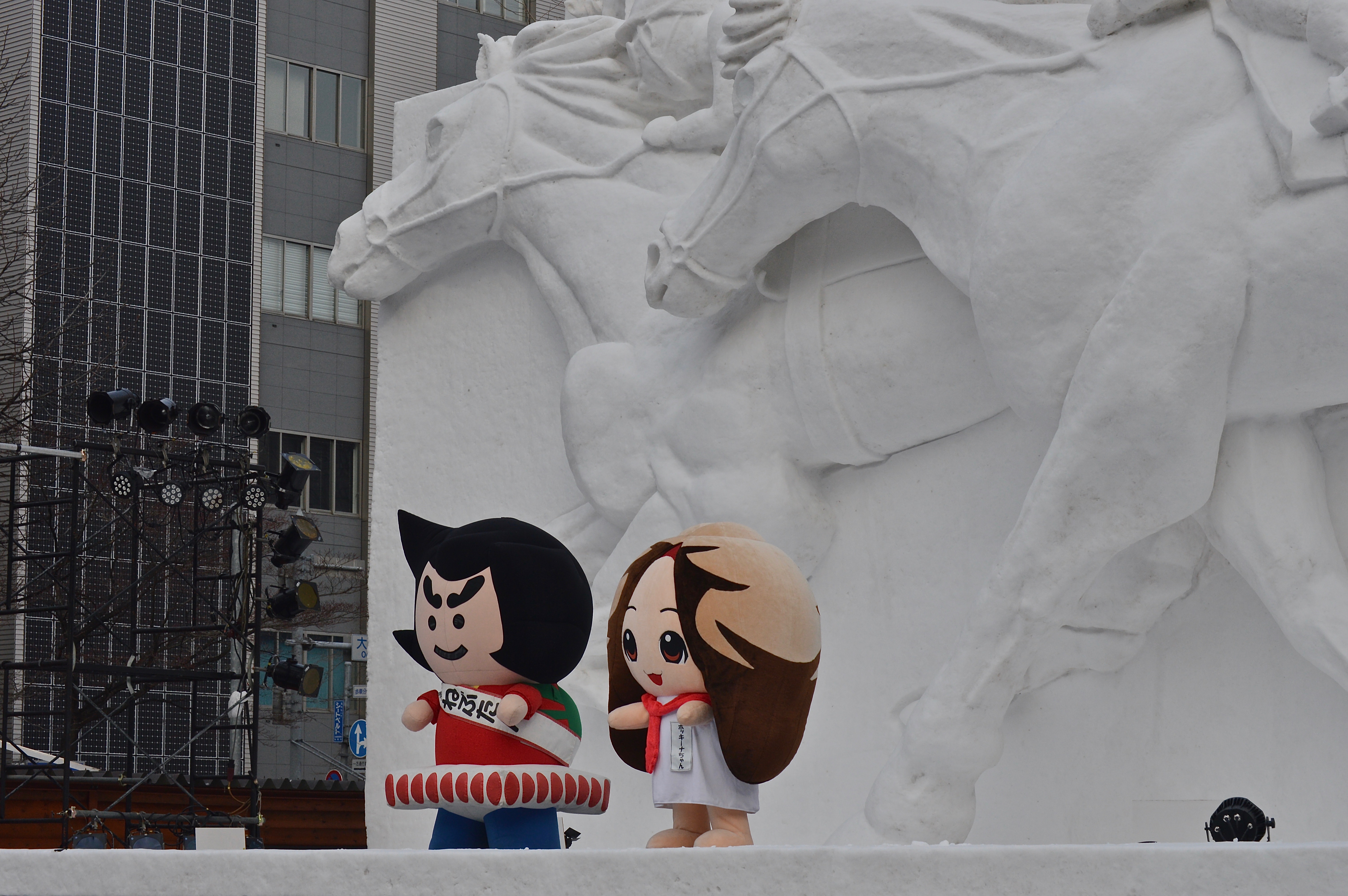
Image 1: Snow and anime go hand-in-hand here in Japan.
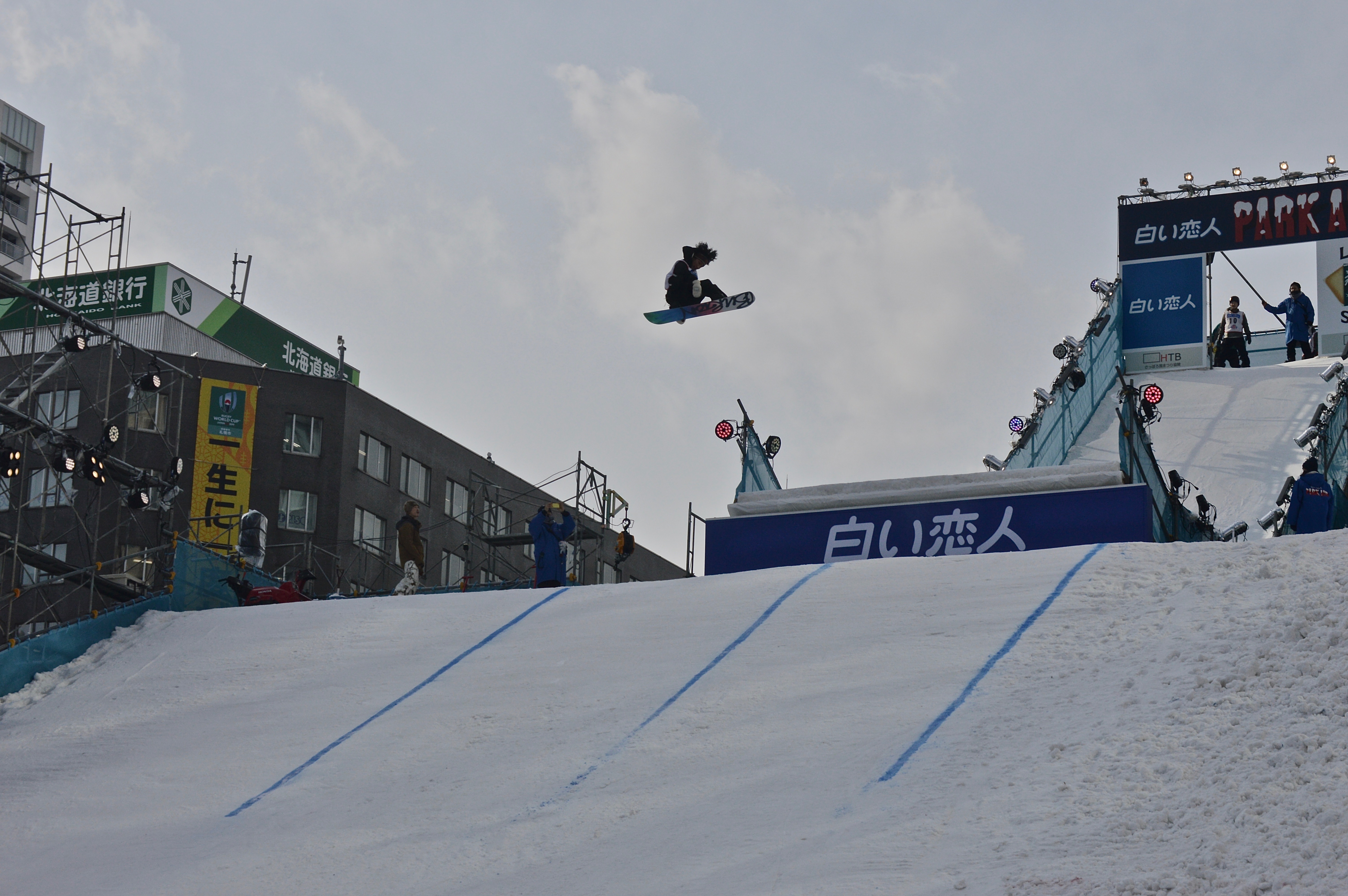
Image 2: A snowboarder airs it out in the Park Air snowboard competition.
Image 3: A Star Wars themed snow sculpture.
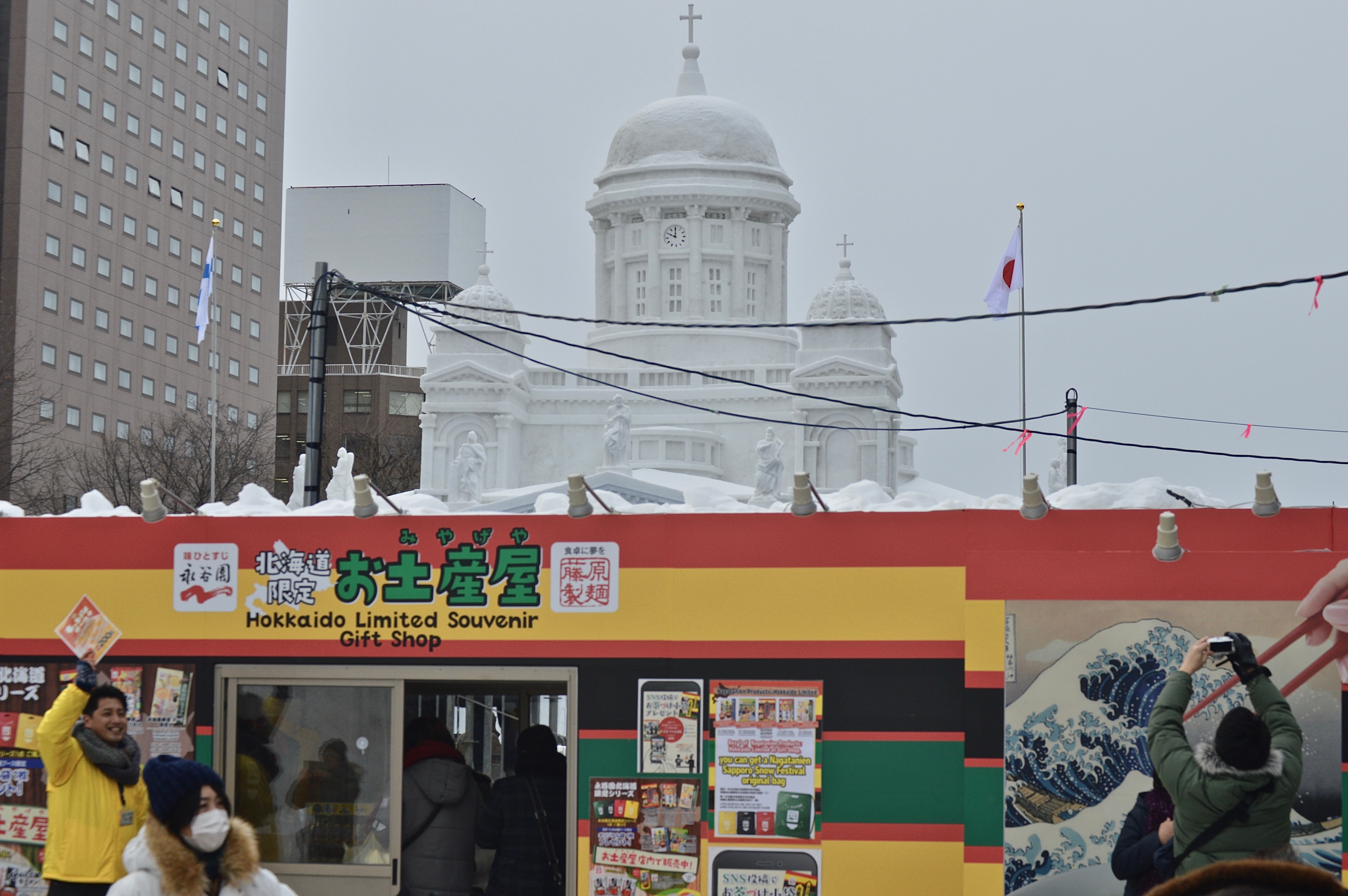
Image 4: The main display is so detailed, it almost blends into Sapporo’s downtown skyline.
Image 5: Food stalls offer all sorts of Japanese treats to visitors.
Image 6: High in the Sky.
From party-going backpackers at the Full Moon Party on Koh Phangan, dive enthusiasts on Koh Tao, rock climbers in Krabi, honeymooners and families on holiday on Koh Samui and Koh Phi Phi, the islands in southern Thailand offer something for just about everyone. As a result, many have become increasingly popular and crowded over the years, especially during the drier winter season. The reality of secluded white sand beaches meeting vibrant turquoise waters, where your only company is that of the gentle offshore breeze and a few picturesque wooden longtail boats anchored off the beach, has become mostly a myth at this point. Instead, many of these islands are now home to trash-littered beaches, overcrowded tours, and hiked up prices.
Except for this one largely yet to be discovered island off the coast of Krabi: Koh Lanta.
This sleepy, slow-paced island has yet to be claimed by The Beach effect (Maya bay on Koh Phi Phi–where the famous movie starring Leonardo DiCaprio was filmed–is closed indefinitely due to environmental damage from heavy tourist traffic) and remains relatively undeveloped compared to holiday hotspots like Phuket and other Thai islands. On Koh Lanta, one can still find empty beaches and seclusion from the crowds to truly get away from it all.
I went to Koh Lanta after a wild–and sleep deprived–week ringing in the New Year in Chiang Mai and needed some beach time to relax and recover, and that’s exactly what I found.
The Beaches
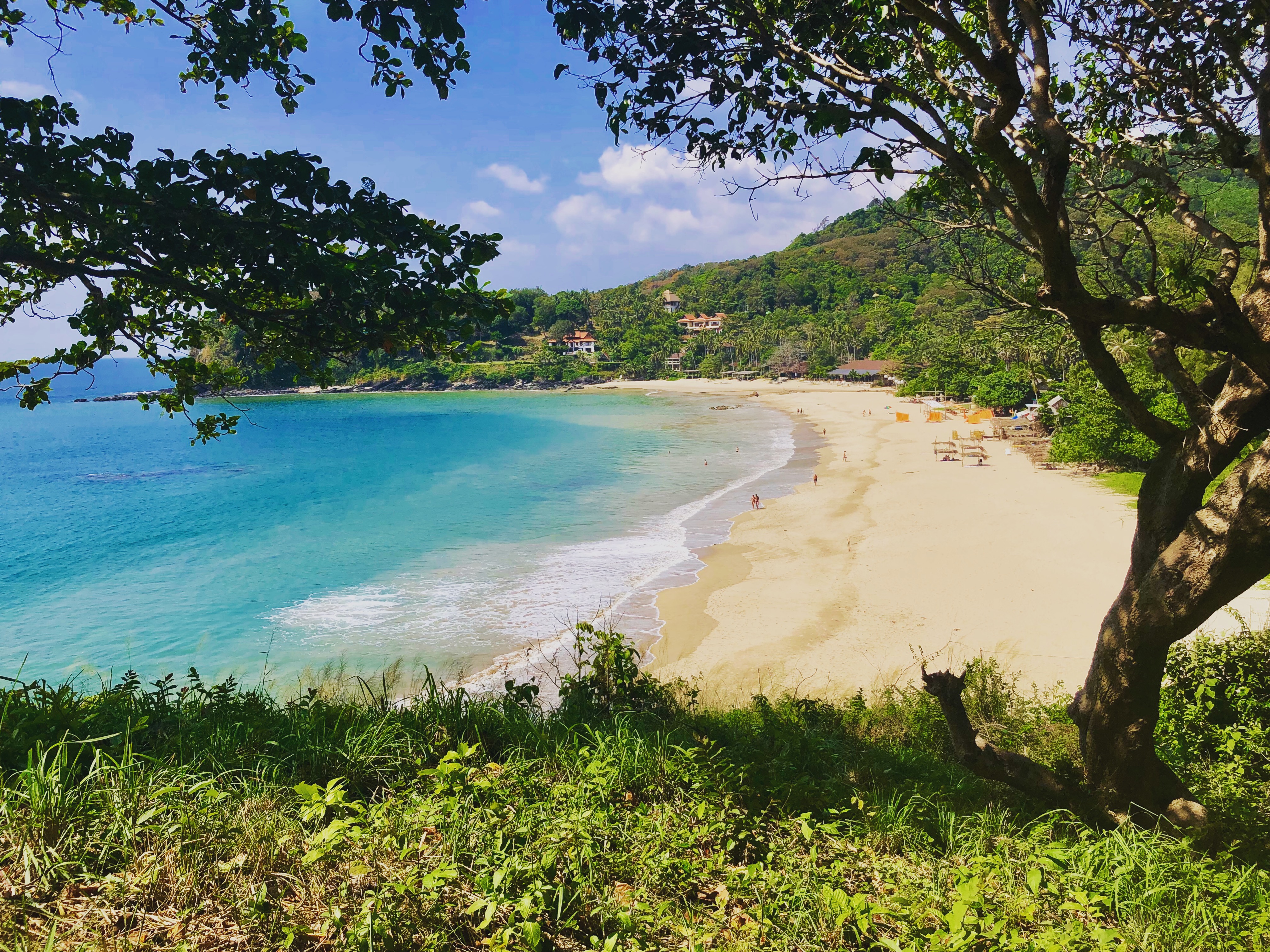
Easily, the best aspect of Koh Lanta is the quiet and idyllic beaches. The entire west coast of the island is littered with, what are in my opinion, the nicest beaches in all of Thailand. Imagine long, wide stretches of fine-grained white sand, calm, clear tropical waters to swim in, and only a few other people to share it with. Or, just take a look at the following photos and see for yourself:


Other beaches include: Nui Bay (small and scenic but can get busy during mid-day), Klong Chak (title image), and Klong Khong (best nightlife, especially at the Mushroom Bar).
What to Do
Rent a Motorbike
The easiest, and cheapest, way to get around Koh Lanta is via motorbike. Renting one will cost around 200 baht per day for an automatic bike (you can get a small discount if you rent it for multiple days). While riding motorbikes on many of the other Thai islands (particularly Koh Phangan), and just driving in Thailand in general, can be extremely dangerous, there is hardly any traffic on Koh Lanta and only a few roads, making it near impossible to get lost. It is actually a great place to learn if you’ve never driven one before! However, do use caution if you choose to drive yourself as the roads can have many potholes and Thai drivers can be very unpredictable.
Head south towards all the beaches mentioned above; the further south you go, (generally) the quieter the beaches will get. I spent most of my days driving around and beach hopping on my motorbike.

At the southern tip of the island is a National Park with a few hikes and another secluded beach. I didn’t go because I’m quite poor and the entrance fee costs 200 baht (and the beaches are free!).

Browse the markets and shops of Old Town on the east side of the island.
Go north to the quieter Koh Lanta Noi and drive through the countryside and past small local villages. This part of Koh Lanta is virtually void of tourists and offers a small glimpse of local island life.

Explore!! There’s only one road that goes around the island and a few that cross it, but it’s easy to get away from it all here. I could have easily spent another week driving around and discovering new spots.
4 Island Tour
If you’re feeling as if you actually need to do something instead of wasting away the days sun bathing on the beach, the 4 Island Tour is a popular option (but is there anything really that wrong with relaxing on the beach all day? Didn’t think so). I’m usually not a fan of tours or “Top-things to Do,” as they are often overcrowded and overpriced tourists traps; however, this tour, though still being overcrowded, is well worth the 700 Baht price and brings visitors to some incredible sights.
The four islands include Koh Ngai for snorkeling and beach time, Koh Mook for the majestic Emerald Cave and lunch on the beach, and more snorkeling on Koh Chueak and Koh Kradan.

The highlight of the trip is the Emerald Cave–a true geologic wonder that is only accessed by an 80 meter swim from the open sea through a tight dark tunnel before it opens up to a small emerald pool and sandy beach in the middle of the island. The beach is surrounded by immense steep cliffs on all sides and can only be seen from the sky above, making it the perfect little secret hideout. Legend has it, pirates once used the cave to safely store their treasure. It’s a refuge even Robinson Crusoe would have been jealous of!


My only complaints of the tour is that it is overpacked with people (but that’s how it always goes) and much of the time is spent on the boat, leaving little time to actually enjoy the stops. Although, for 700 Baht (including lunch and snacks), it is one of the more reasonably prices tours I’ve found on any of the Thai islands and allows you to see some of the lesser visited islands in the area. If you are with a group, I would, instead, recommend hiring a private longtail boat for a day (about 7,000 Baht for the boat), allowing you to visit the same places without the huge crowds of people.
Enjoy the Sunsets!
Koh Lanta has some incredible sunsets and a number of bars and restaurants offering seaside views where you can watch the sun go down while enjoying a delicious local Thai or seafood meal.


These are just a few of the reasons Koh Lanta has become my favorite island in Thailand. I would highly recommend a visit if you are planning a trip to the Land of Smiles, but please, please, please (I seriously can’t emphasize this enough) travel responsibly and sustainably so this magical place doesn’t end up like all those other crowded, polluted Thai islands. Remember to always be mindful of buying single-use plastics, where your waste ends up, and how your actions affect the local environment and communities.
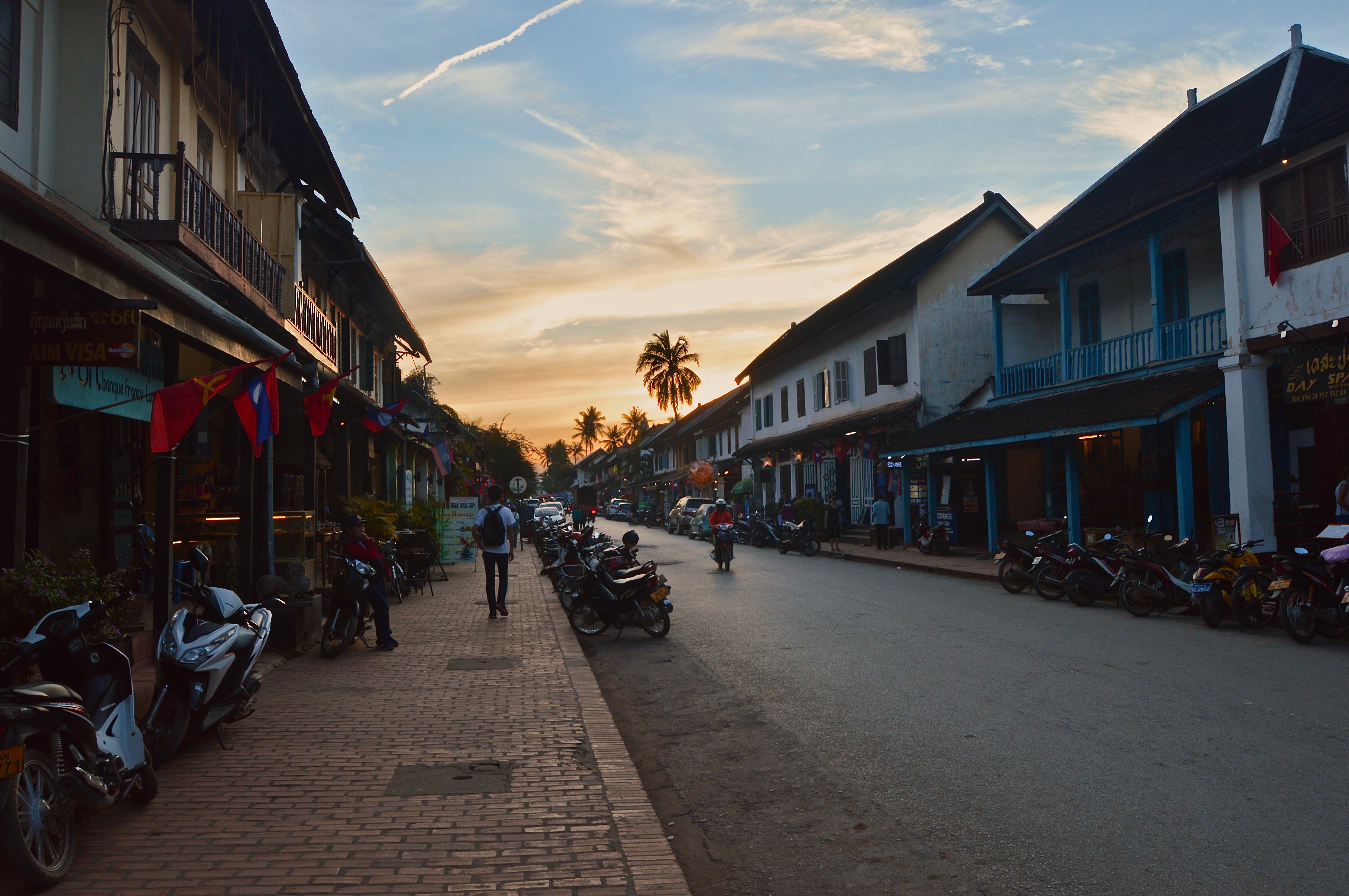
Luang Prabang, located at the confluence of the Mekong and Nam Khan rivers in northern Laos, is the ancient capital of the country and often referred to as its cultural capital by those who visit. Characterized by ornate Buddhist temples, French-influenced colonial architecture, scenic natural landscapes, a vibrant night market, and dozens of quaint cafés and bakeries, this sleepy town along the Mekong River is a must-visit for travelers in Southeast Asia.
I spent a week here riding motorbikes through the jungles and rice fields, eating delicious dishes (Laotian food may be my favorite in all of Southeast Asia as it is a fusion of local flavors and French-inspired cuisine. Plus, everything comes with a baguette!), and wasting away the days reading and lounging in riverside cafés along the scenic Nam Khan. Although there are many activities and day trips offered, Luang Prabang is the perfect town to relax and do absolutely nothing in, while enjoying the peaceful atmosphere of Laos.
Enjoy this photo gallery which shows but a small snippet of Luang Prabang’s beauty…
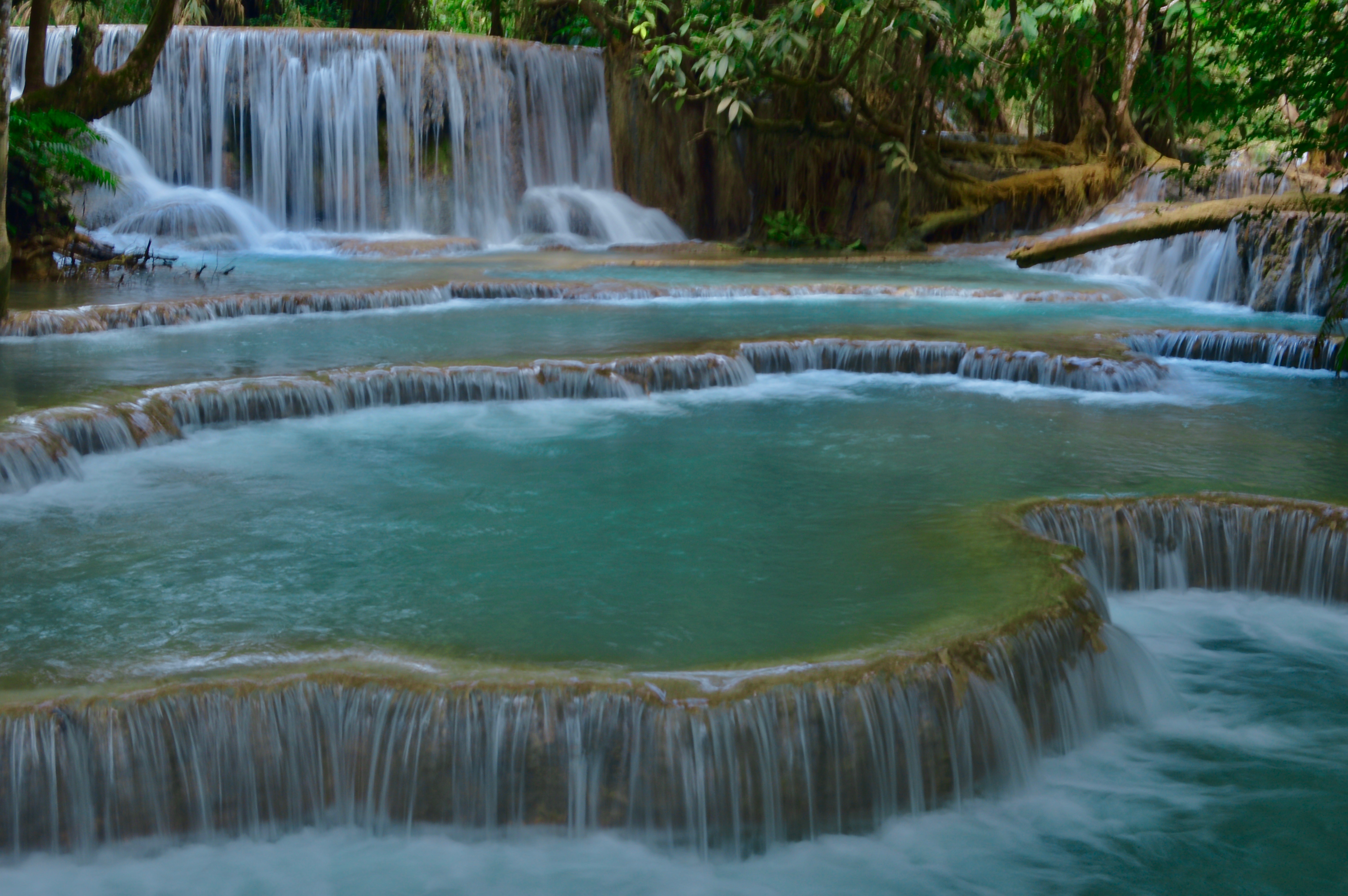
Featured Image: One of the lower falls at Kuang Si waterfall–the most popular day-trip from Luang Prabang and the one must-do activity while in the area.
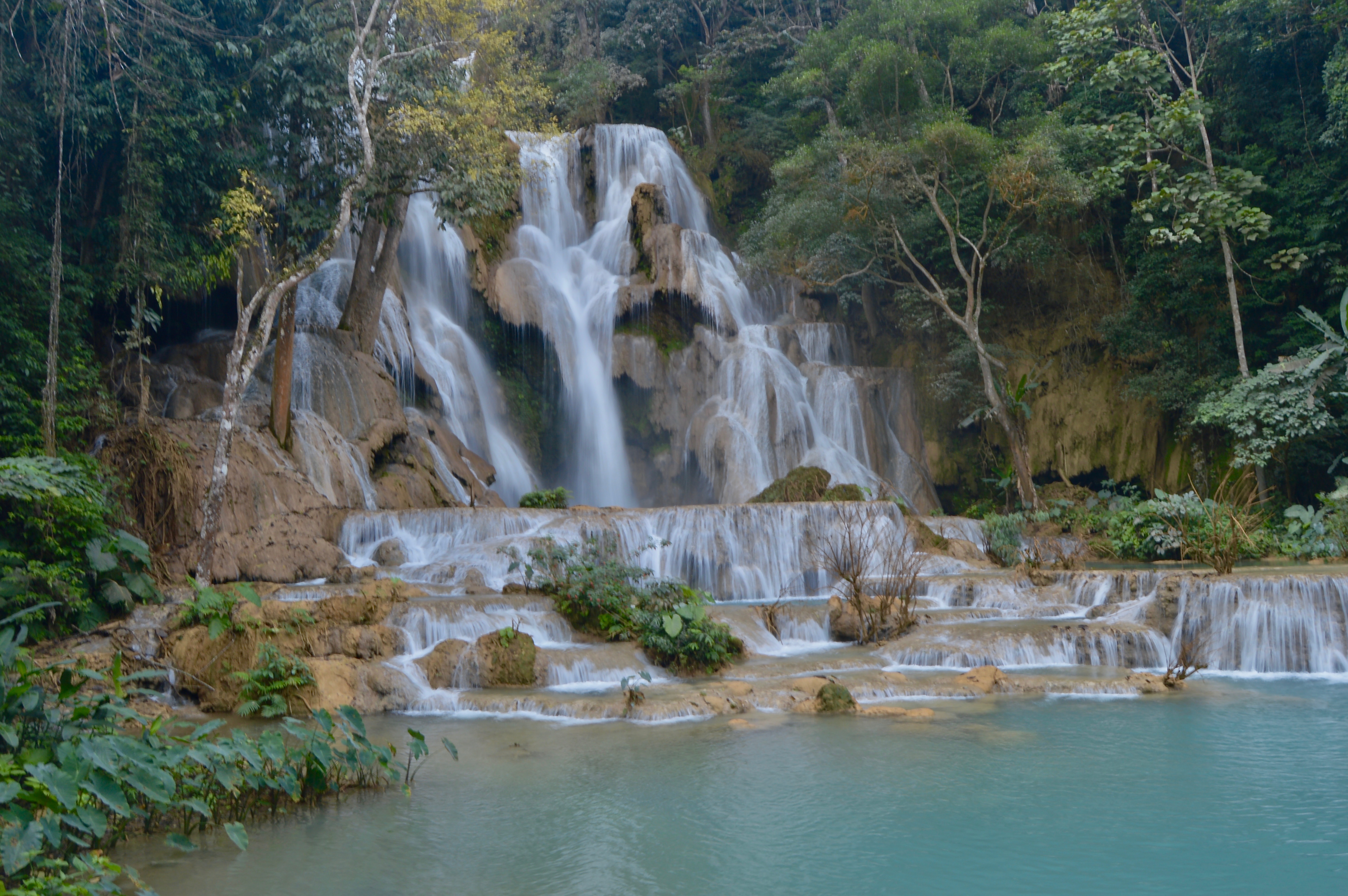
Image 1: The main Kuang Si waterfall. The vibrant emerald color of the water is derived from the salts and minerals collected as the water flows over the limestone creek bed.
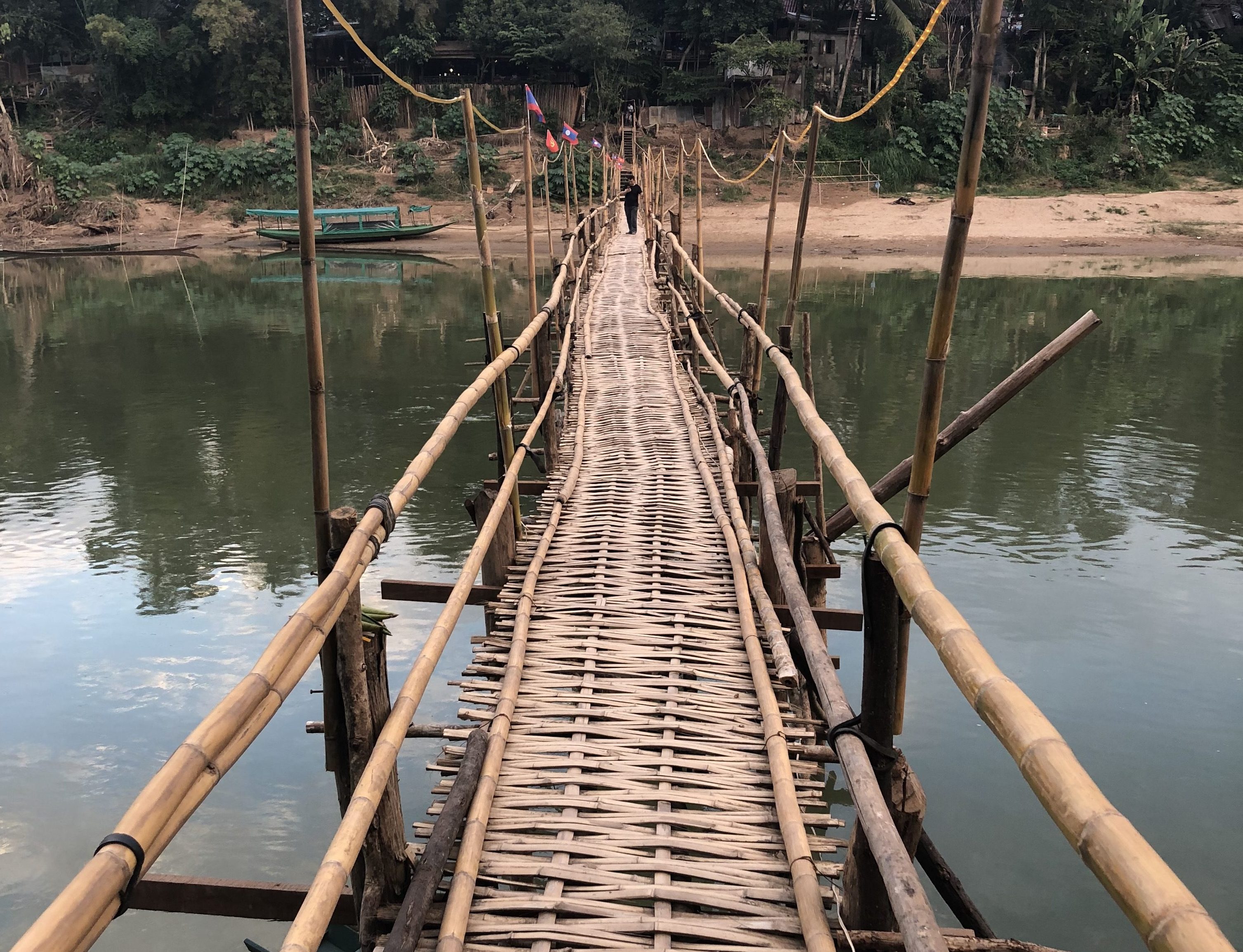
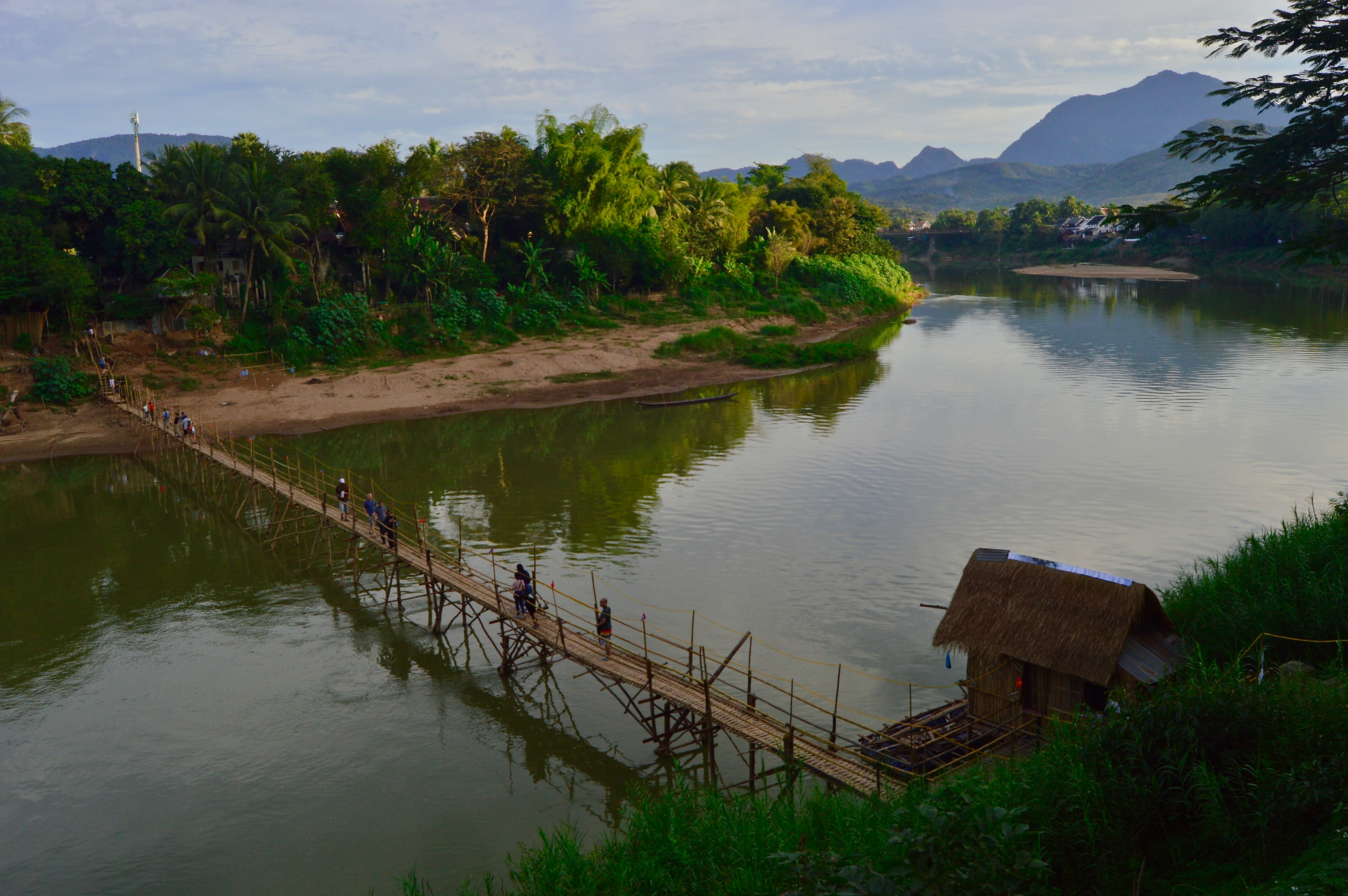
Image 2: Tourists cross the famous bamboo bridge to reach the other side of the Nam Khan river, the much quieter side of Luang Prabang. Each year, during dry season–when the river is at its lowest, locals construct this bamboo footbridge bridge across the river, taking it down ones the rains begin at the end of winter.
Image 3: The main street of Luang Prabang is lined with French colonial buildings and many bakeries, cafés, and restaurants offering a taste of the city’s famous food scene.
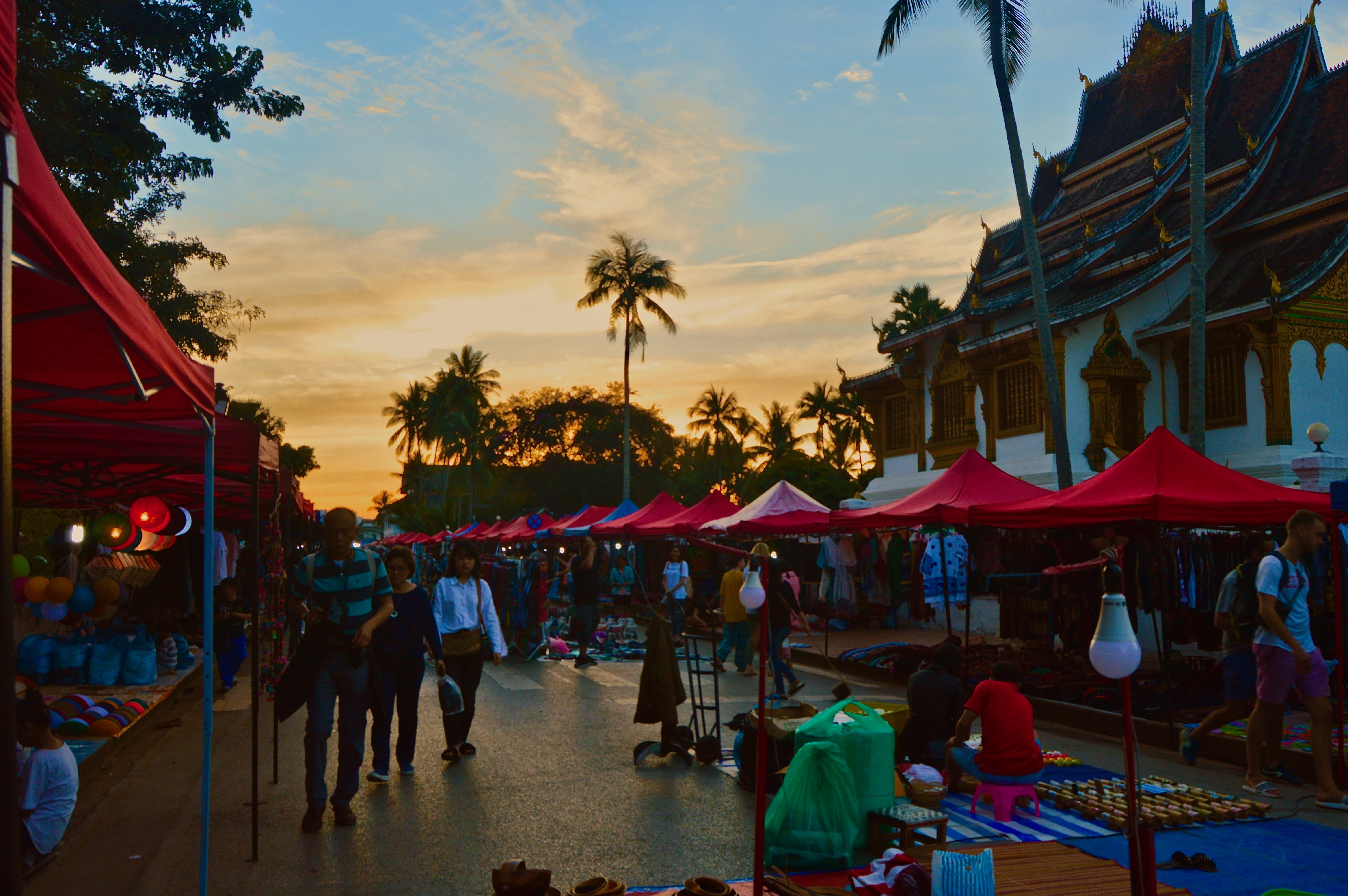
Image 4: Every evening, the night market in the town center is flooded with tourists browsing among locally produced souvenirs and handicrafts.
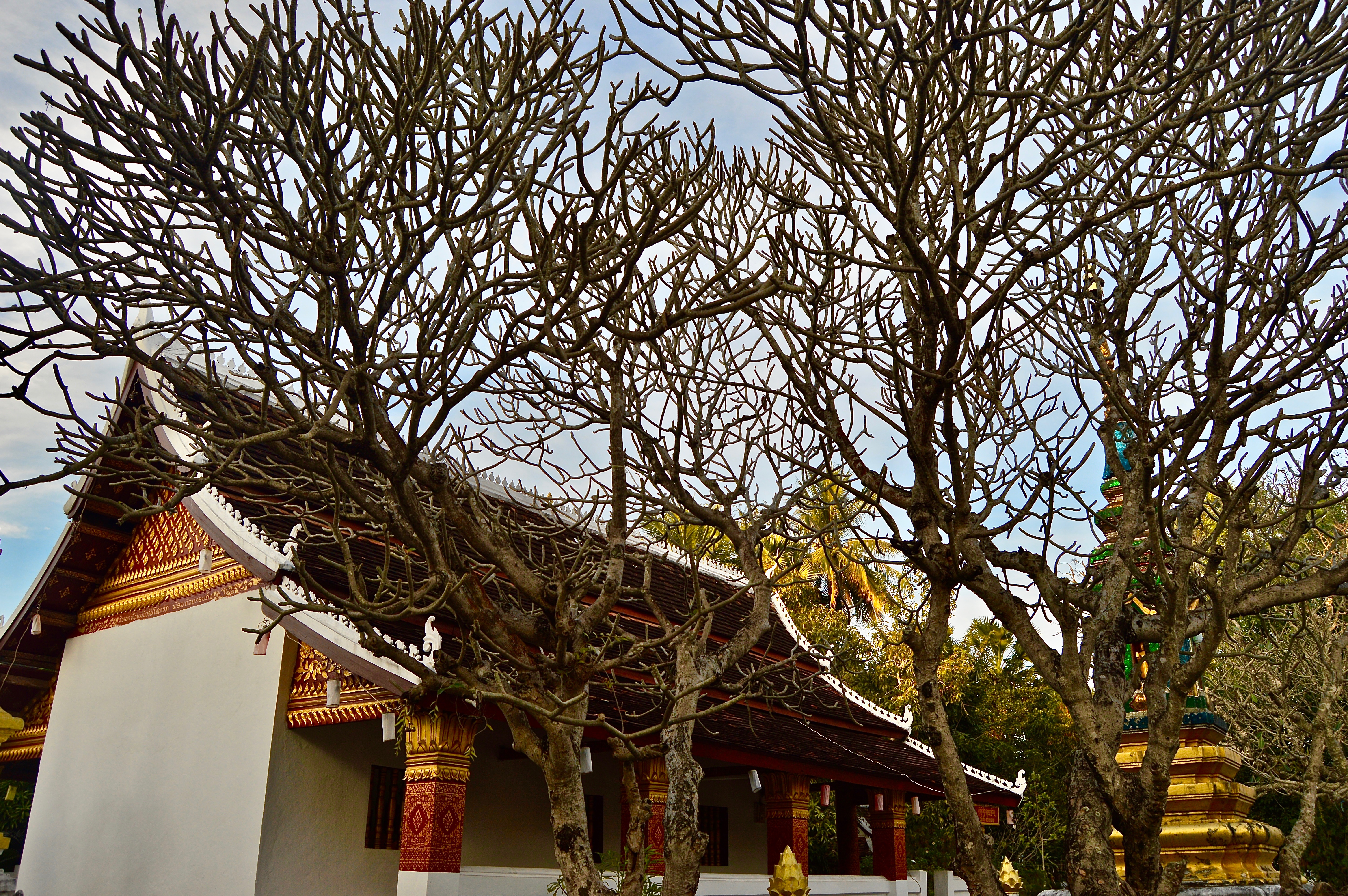
Image 5: Golden Buddhist temples can be found throughout the city.
One of the most popular tourist routes in India connects the capital city of Delhi to Agra–the home of the Taj Mahal–and the Pink City of Jaipur. As the cities are located relatively near each other and form a distinct triangle shape on a map, this route has been dubbed the “Golden Triangle.”
Full of fascinating history and sublime architecture, the Golden Triangle is abundant with sightseeing opportunities for visitors. However, this is also what makes these such crowded destinations and a breeding ground for tourist traps and scams.
If you can get past the deceitful tuk tuk drivers and aggressive street peddlers, the Golden Triangle hosts some of India’s most brilliant sights and monuments. The photos in this gallery portray some of the most popular sites along the route, though still merely a fraction of all there is to see while traveling India’s Golden Triangle.
Disclaimer: only Agra and Jaipur are featured in this gallery as I only spent a couple days in Delhi and did not have the time to visit the monuments there. Popular sites in Delhi include the Red Fort, India Gate, and Akshardham, among others.
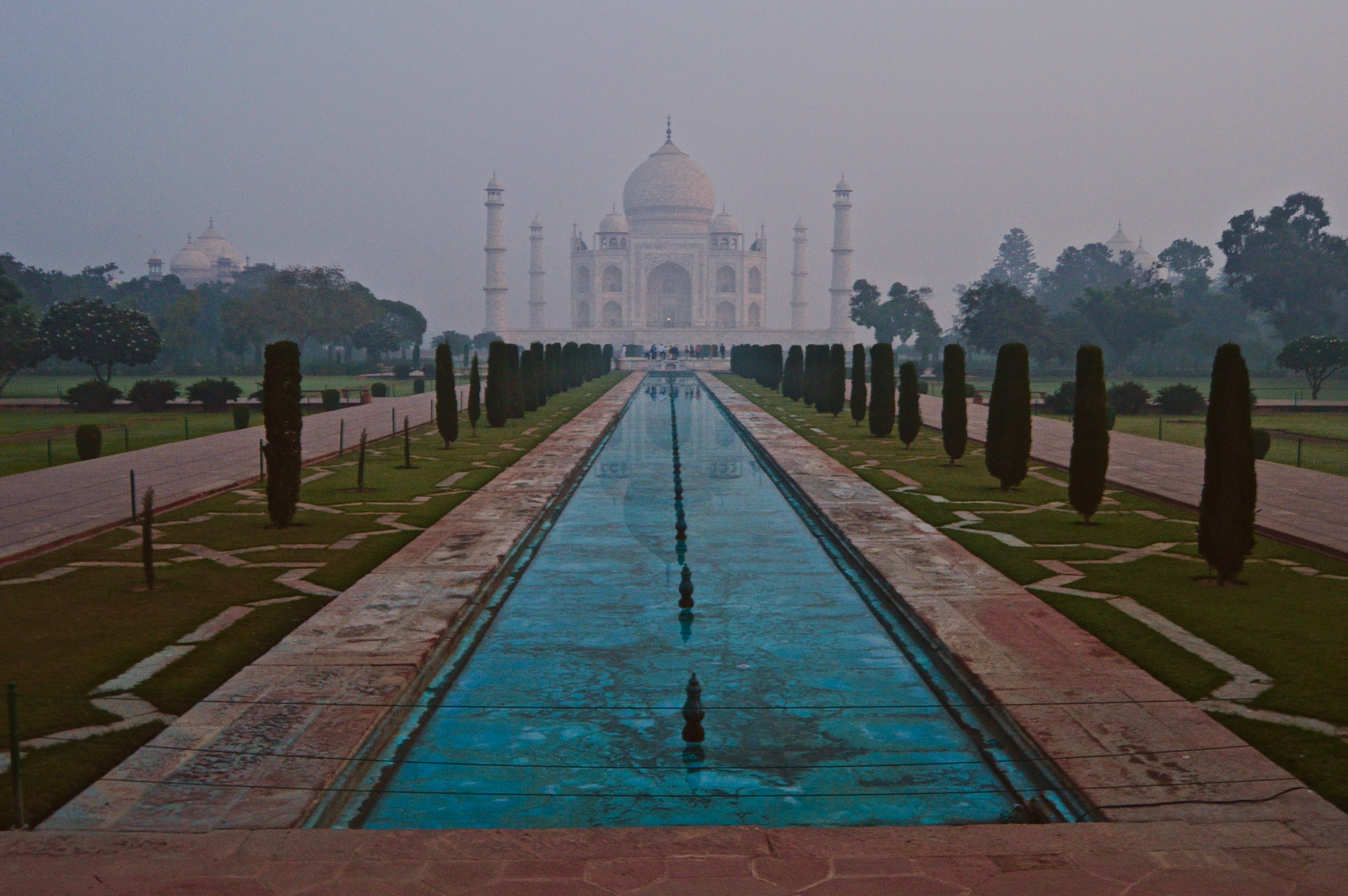
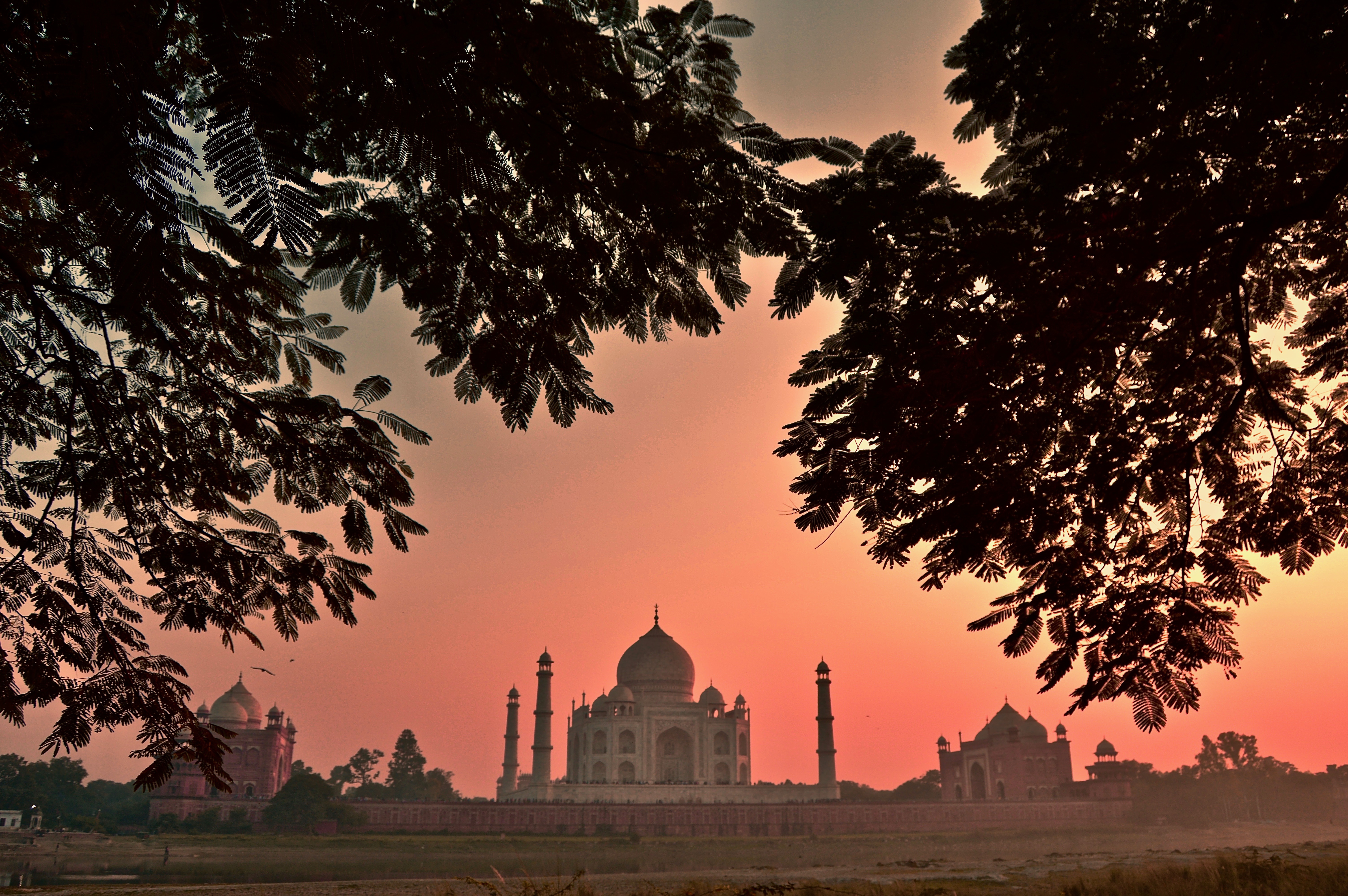
Featured: The Taj Mahal viewed just before sunrise from the main entrance gate.
Image 1: The Taj Mahal at sunset from the opposite side of the Yamuna River.
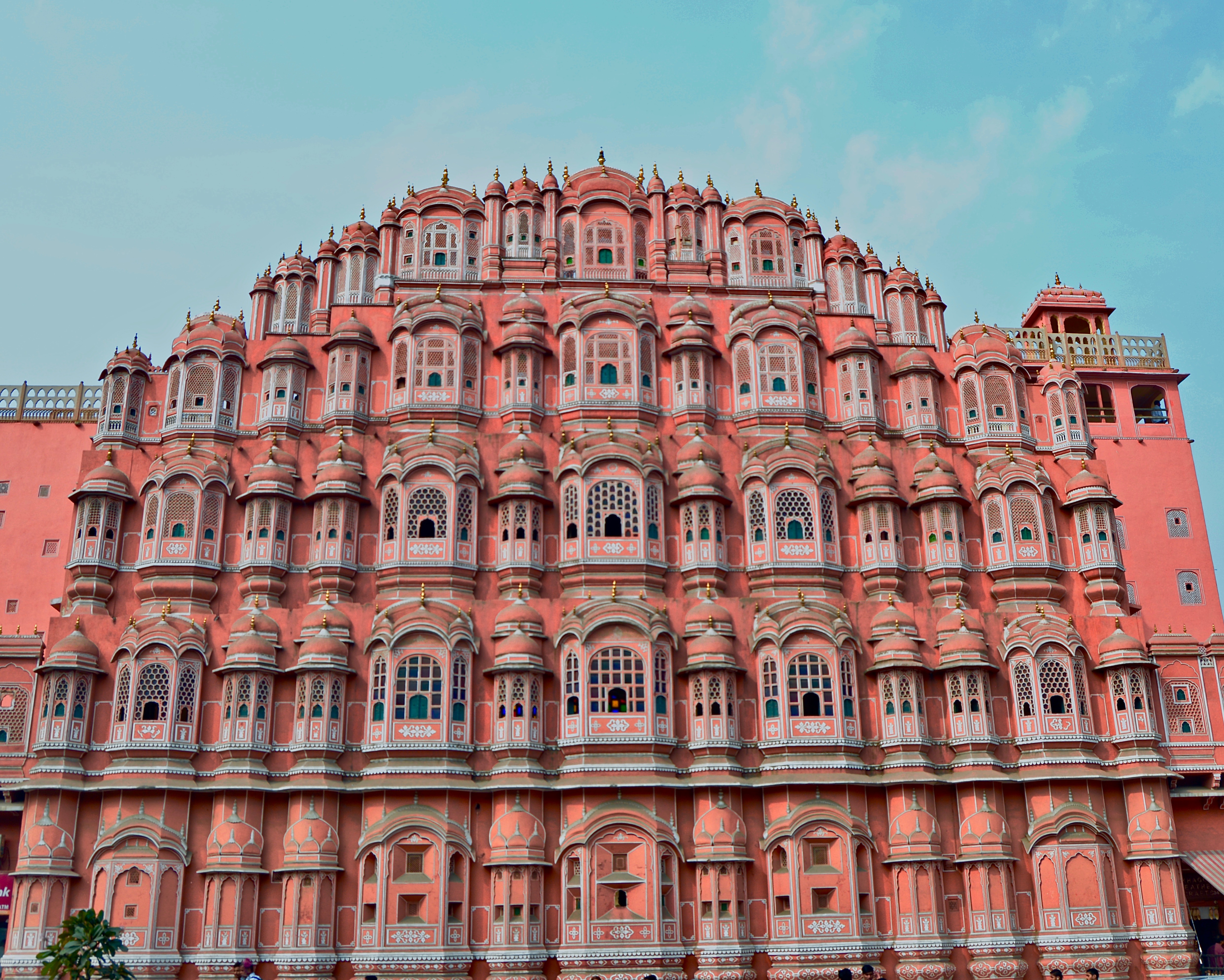
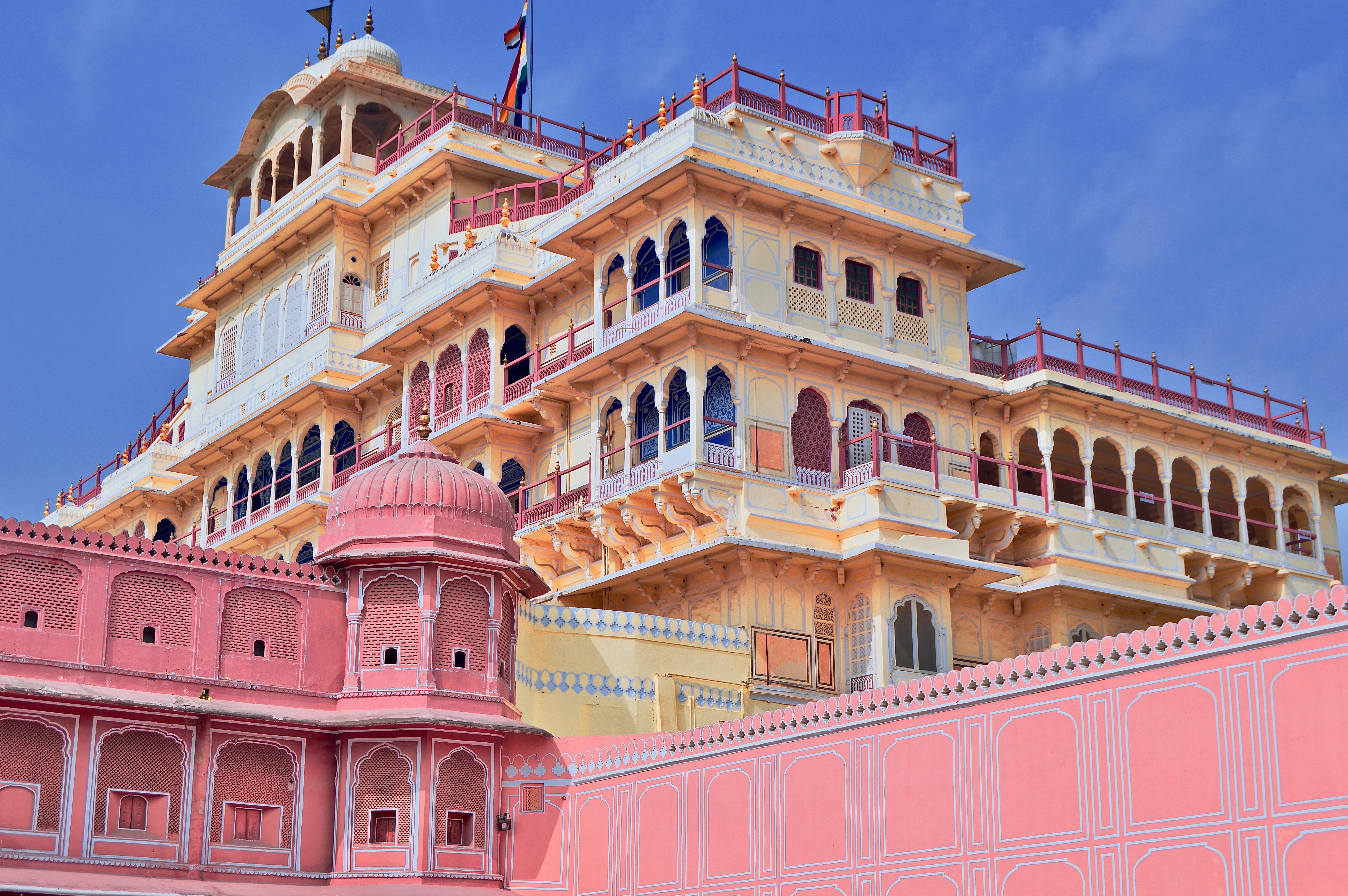
Image 2: The Hawa Mahal, or “Palace of the Winds,” in Jaipur.
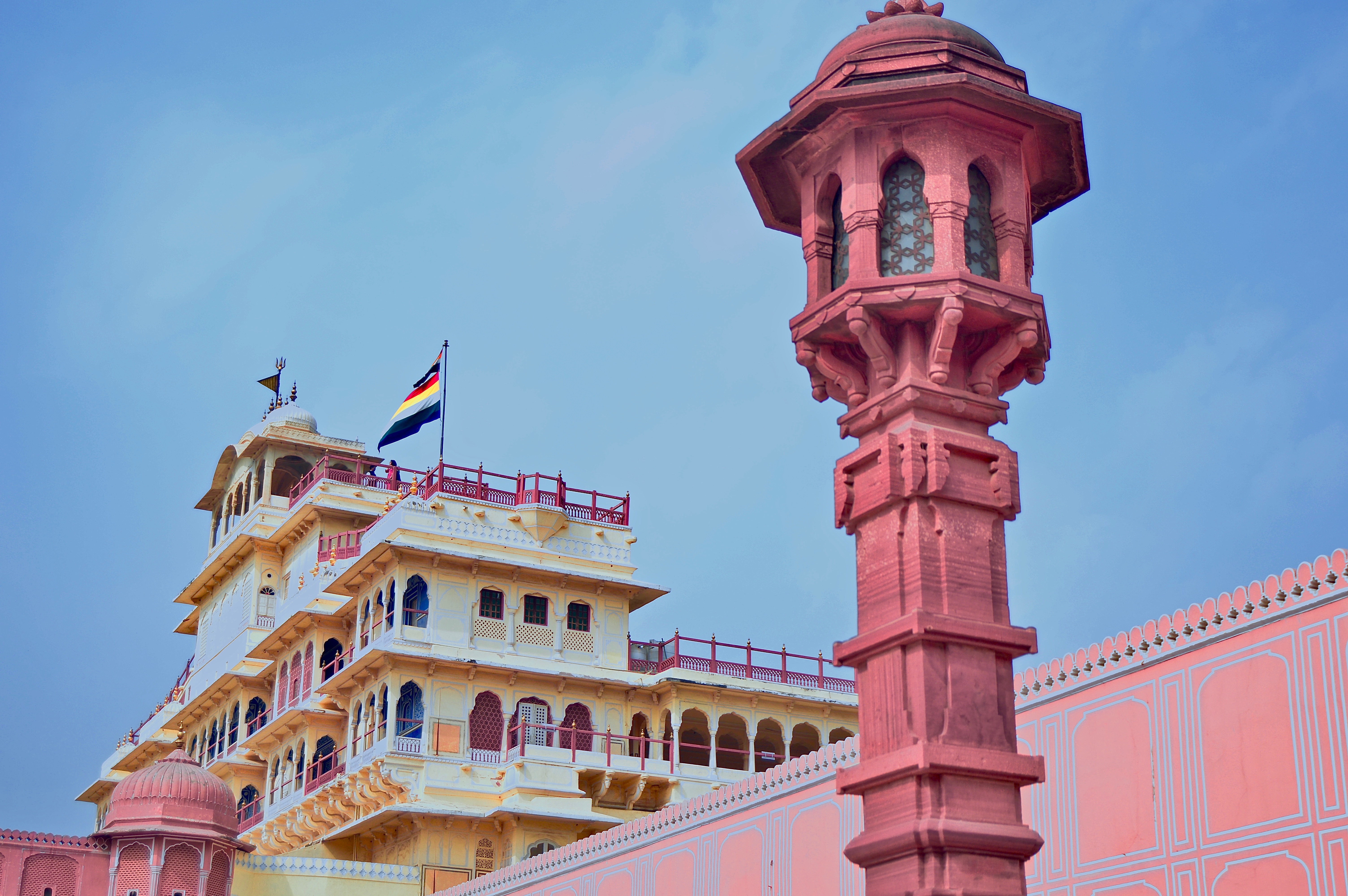
Image 3: The Chandra Mahal in Jaipur’s City Palace.
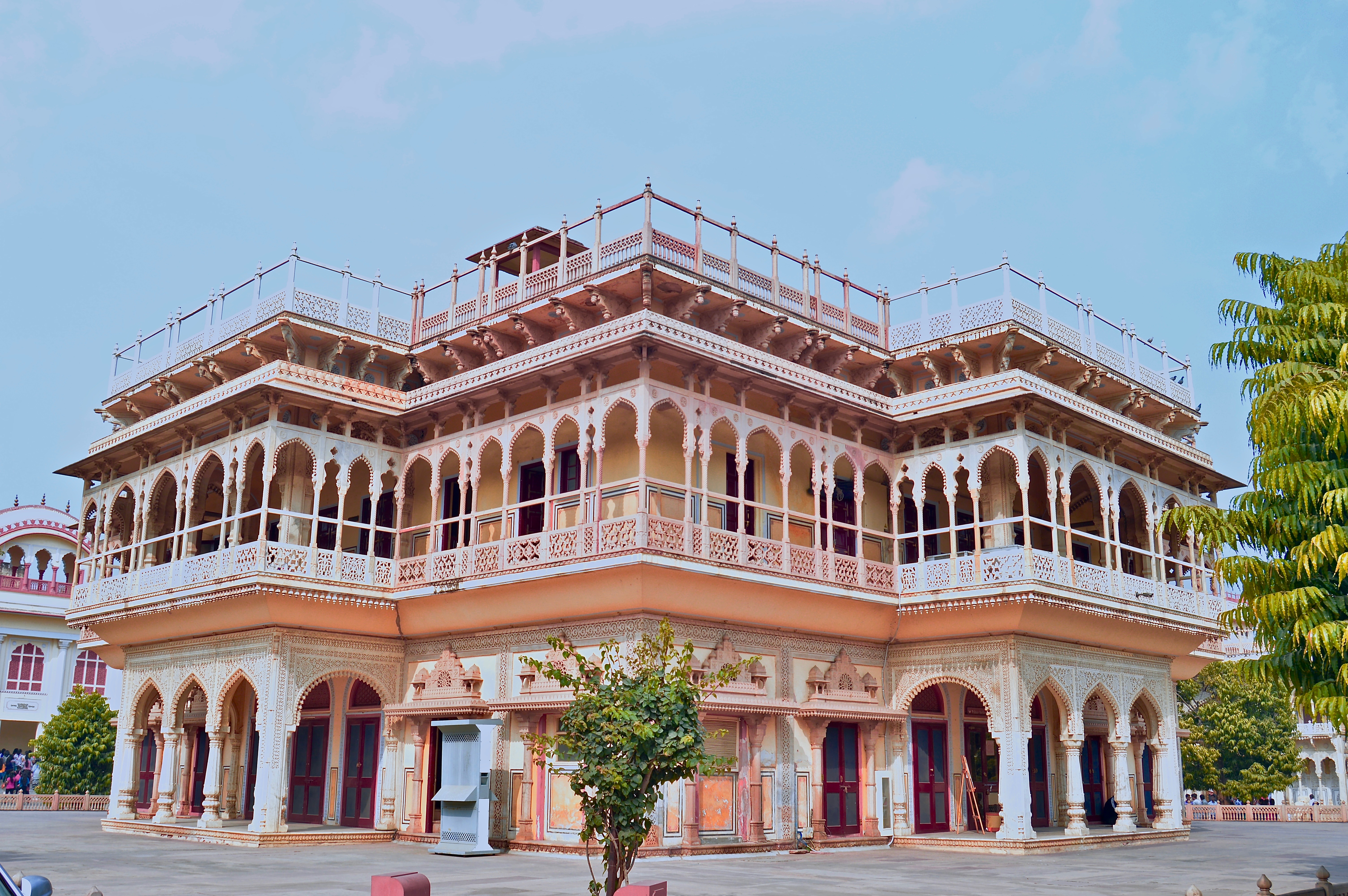
Image 4: The Mubarak Mahal, also located within Jaipur’s City Palace complex.
Image 5: It is easy to see why Jaipur is called “The Pink City.”
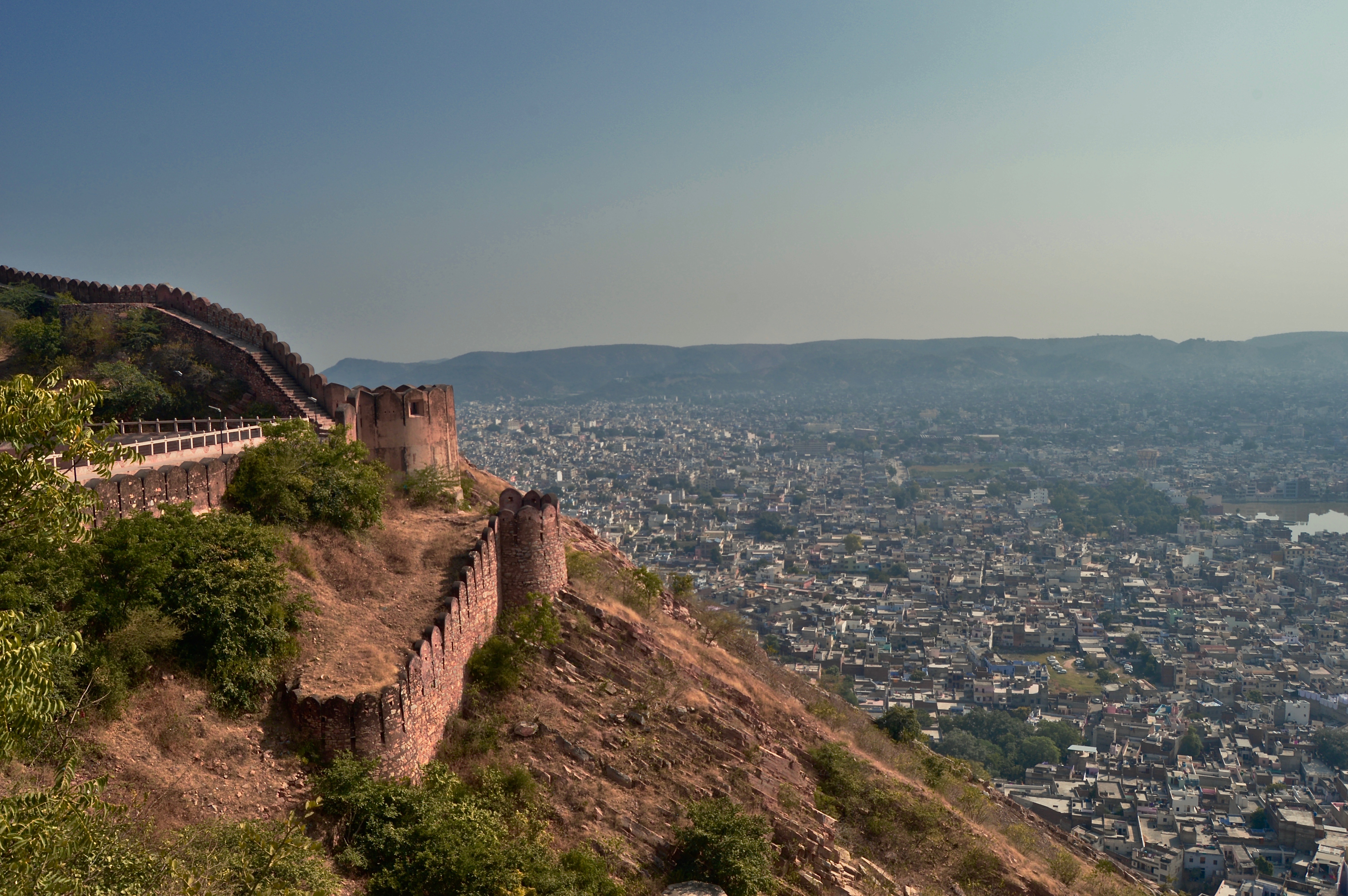
Image 6: The view from Nahargarh Fort, overlooking the city of Jaipur.
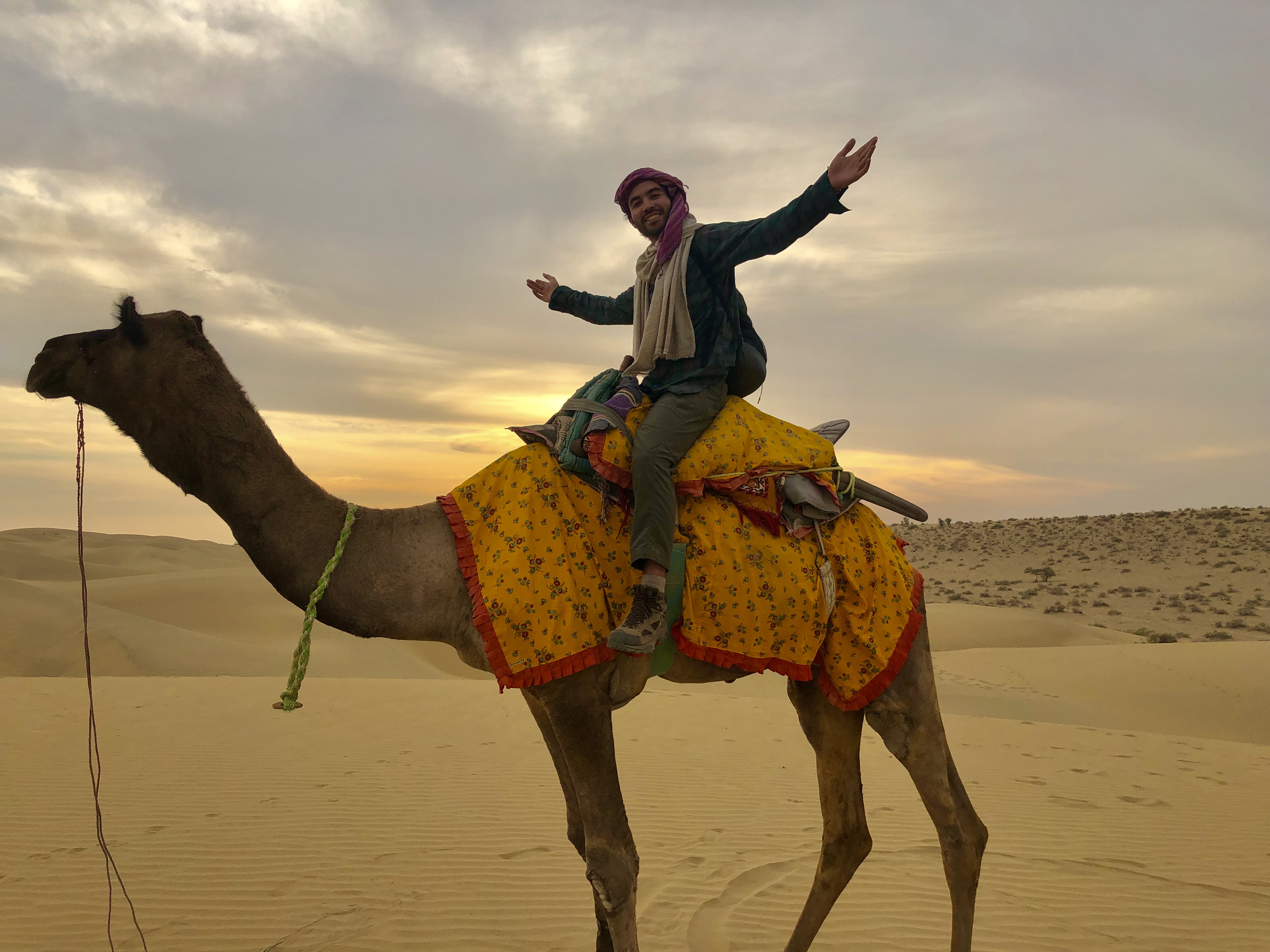
There are several images that come to mind while envisioning a trip to India: historic monuments such as the Taj Mahal, bustling cities like New Delhi or Mumbai, the tropical waters of Kerala or Goa, sacred temples and places like Varanasi, mouth-watering cuisine, and diverse and festive culture. But riding a camel through a desolate desert? Not particularly. Morocco or Egypt seem more fitting for that. However, when I first began researching for my India trip, I found that camels are indeed widely prevalent in India, especially in the western state of Rajasthan. Camel safaris are offered in the city of Jaisalmer, allowing visitors to follow in the footsteps of Silk Road traders and get a feel of life in the desert. This immediately went to the top of my India itinerary.
While visiting Jaisalmer, the Indian city located in the heart of the Thar Desert, (read my post on Jaisalmer here) you will inevitably hear multiple times about the opportunity to go on an overnight camel safari. Nearly every hotel has their own safari business, and there are dozens of independent tour companies offering similar services as well. With an abundance of options, it is advised to read reviews and ask around, as there is a wide range of tour prices and quality, and some are better than others. I went with a small independent company called The Real Deal Rajasthan Camel Safari and had an excellent experience that I would recommend to anyone visiting Jaisalmer.

The Real Deal offers several different tour options from one day to three night trips, luxury camping in a tent with a bed and hot shot showers, to sleeping outside under the stars. Some packages include a night time cultural program with traditional music and dances. Most people do an overnight trip, arriving at camp for the sunset and dinner and heading back to Jaisalmer after sunrise and breakfast the next morning. I opted for the basic 2 Day and 2 Night option, costing about 45 USD (the price is surprisingly cheap as it includes a guided camel ride, all your food–and plenty of it, and a bed and blankets for the night). For under 25 USD per day, this is a bargain! I likely would have spent more just for my hotel and food for a day in Jaisalmer.
The first day, it was just me and an older French couple, who were doing an overnight trip. We left Jaisalmer at 2PM and drove about two hours out into the desert with our guide, and owner of the company, Fatan. Along the way, we stopped at an old abandoned village where Fatan taught us how the homes were built, using a mixture of stones, cow dung, and mud, and thatched roofs constructed with sticks from the desert bush; this technique is still often used today in some of the small villages. Vibrant blue peacocks and, of course, camels were abound all along the road as we drove deeper into the desert.


Around 4PM, we reached a little village where our guides and camels were waiting for us. My camel was a male of six years old by the name of Kilta. This was the first time I had ever viewed a camel from up close, and I can honestly say they are some of the most awkward-looking and ugliest creatures I’ve come across, but at the same time, quite charming and–almost–cute. Kilta was close to 10 feet tall when he stood up straight and nothing about the proportions of his body seemed to make any sense–the legs and neck were way too long, the head and teeth much too large. The way in which they walk is almost comical, as their long lanky legs seem to snap outwards with each step, resembling the way Woody’s steed, Bullseye would gallop in Toy Story. A camel is like that tall awkward middle schooler who hadn’t quite grew into his frame yet, and whose height far outpaced his coordination. Despite the odd outward appearance, camels are perfectly adapted to a life in the desert. While they are capable of eating and drinking A LOT at a time (as I would learn over two days of riding them), they can go up to a week without food or water.
We rode for about an hour to the campsite, which was nestled on a long stretch of sand dune. I had expected to see many other tour groups there as well, but we had only come across one, and their camp was a few hundred yards way, hidden by the tall dunes. We had this piece of sand all to ourselves, and this is where all the magic happened.

The camp was small and just consisted of two open makeshift open-air shelters–one for the kitchen and one for the beds–constructed with wood scavenged from the desert. Fatan and another guide were already there waiting for us and preparing dinner over the campfire. With a cup of masala chai in hand, I watched the sun set over the distant desert while waiting for dinner. The meal consisted of Aloo Gobi (potatoes and cauliflower sautéed in Indian spices), with rice, dal, and homemade chapatti. It was a feast comparable to anything I would receive in an restaurant, and as it always goes with camping and cooking over the fire, tasted even better out in the desert.

Fatan told us how during his childhood, this is how he and his family used to live–desert nomads who constantly moved around, grazing their herds of camels, constructing makeshift shelters like this and cooking dinner over the fire every night. No one really lives like this anymore, he explained to us. Most families now live in the villages and the father will go out for days at a time to graze the camels before returning to the village. Fatan was part of the last generation of true desert nomads.
We sat around the campfire telling stories until darkness overtook us and we retired to our cots, spread out over the sand, under the expanse of the clear night sky.

The next day, the French couple went back to the village in the jeep with Fatan and I continued on with a new guide, Sambo, and a new camel, Mr. Lucky. We rode for another couple hours, stopping in a small village and then again for lunch. Sambo prepared me another massive and delicious meal over a small campfire (you seriously will not go hungry here). After lunch, we made our way back towards camp.
Sambo spoke some English, but our conversation was mostly strained. We rode most of the way in silence, periodically broken by his out-of-tune belting of John Denver’s “Take Me Home, Country Roads,” where many of the words were placed out of order. This irritated me at first, but by the end I was singing along as well. Other than those moments, the desert held an eerie silence as I gazed out across the expanse. I imagined what it must have been like for the traders and merchants that spent weeks traveling across the same landscape, looking at the same views day after day, in the hopes of gaining riches upon arrival in Europe. I can at least be certain they had sore butts, as mine was in aching pain by the end of the day. It didn’t help that Mr. Lucky stopped at every bush to stop and feed, completely ignoring my instructions to keep moving on. I mentioned earlier how camels can go up to a week without eating, but that doesn’t mean they don’t enjoy eating, and, boy, did Mr. Lucky like to eat.


At last, we made it back. It was nearly sunset by the time we arrived, so I took my camera and walked across the dunes while Sambo made dinner. The sunset that evening may have been the most impressive one I’ve ever witnessed as it breathed orange and pink flames across the wide open sky.


Back at camp, we were joined by an old desert nomad, a friend of Sambo, who would feast with us and sleep at our camp that night. He and Sambo talked over tea deep into the night while I tended the fire, lost in my own thoughts. This old man was a true soul of the desert, clinging to a traditional way of life, a way so many others have abandoned. His skin was wrinkled from years of wear under the sweltering sun, and his vivid peacock-colored eyes reflected the wisdom of a lifetime of wandering the desert, tending to his camels and learning from the land.
The camels are always set loose at night to wander and feed, and are found in the morning, an event that can sometimes take up to a couple hours. This is one way to distinguish between tour companies that treat their camels well, or, are cruel and abusive to the creatures, as many will tie their legs at night so they can’t wander off (Fatan’s has had his camels for many years and they are considered part of the family, but I have heard that many others are not so kind to their animals. Make sure to take this into consideration before booking a tour).
As I lay in my cot, watching shooting stars dart across the black canvas above, I could faintly hear Mr. Lucky’s bell ringing in the distance, slowly fading off into the night, until sleep gradually overtook me.


