

Here is a little update on my life at the moment:
After 6+ months of travel across two continents and 11 countries, I am now, more or less, settled down in the third and 12th–New Zealand. This small and scenic country in the far corner of the globe will be my home for the next year, where I will be traveling around and working on a Working Holiday Visa.
It’s been over half a year since I left home last August, and it has truly been quite the epic journey for me. From hiking around the European Alps to drinking beer at Oktoberfest in Munich, trekking through the high Himalayas of Nepal and riding camels in the deserts of India, ringing in the New Year with lanterns and fireworks in Chiang Mai, and skiing bottomless powder in Japan, the experiences of the last few months have created memories that will last a lifetime.
Having said that, I am ready to settle down a bit and have a place that feels like home again. I don’t think I will miss the early flights, enduring overnight train rides (no matter how cheap), and not-so-private hostel dorm rooms too much, though they made for plenty of good stories. Perhaps best of all, my bank account will finally be seeing some additions again after constantly dwindling down over the last few income-less months. In other words, I am still traveling, but not quite as the wayward bum I previously was (though still somewhat of a bum).
I arrived in New Zealand a little less than a month ago and have been busy getting myself set up since landing. The first week was spent in Christchurch where I had to do the mundane, but necessary, tasks of setting up a bank account, IRD number, phone plan, and insurance. Oh–and I bought a car! …as well as a whole heap of camping equipment and a mountain bike. So for now, I am all set to explore the wild and scenic landscapes of New Zealand.
But first, I had to find a temporary job as I spent the rest of my money on all these new toys.

Before I left Christchurch, however, I was able to see some old friends from back home–Nathan and Caile–who were on a cruise around New Zealand and docked in the city for a day. Unfortunately, we only had a few hours to spend together, but were able to catch up and make the most of it, highlighted by a scenic gondola ride up to a viewpoint overlooking the city and sea. How crazy it is to run into old friends from home in the other corner of the world!

I found a job on an apple orchard near Cromwell in Otago, where I have been for the last couple weeks. I was able to make a mini road trip out of drive here from Christchurch as I rode some bike trails at Mt. Hutt, visited Mt. Sunday–the filming location for the city of Edoras in the Lord of the Rings films, and took a scenic detour up the highway to Mt. Cook/Aoraki.


The orchard work is difficult, but rewarding, and I have made many new friends as there are about 15 of us here–all backpackers. We work together, cook, together, and party together.
I plan on staying here and working until meeting up with parents, who arrive in just over two weeks. I will travel with them for about a month, before settling down for a winter of working and skiing in Queenstown.
I have been in New Zealand for less than month, but I already have the sense that this is somewhere I could live. All the places I have visited thus far have brought me great enjoyment, but now it feels as if that chapter of my journey is ending, giving way to a new one. One that will surely be full of joy and adventure in this small, yet grand country.
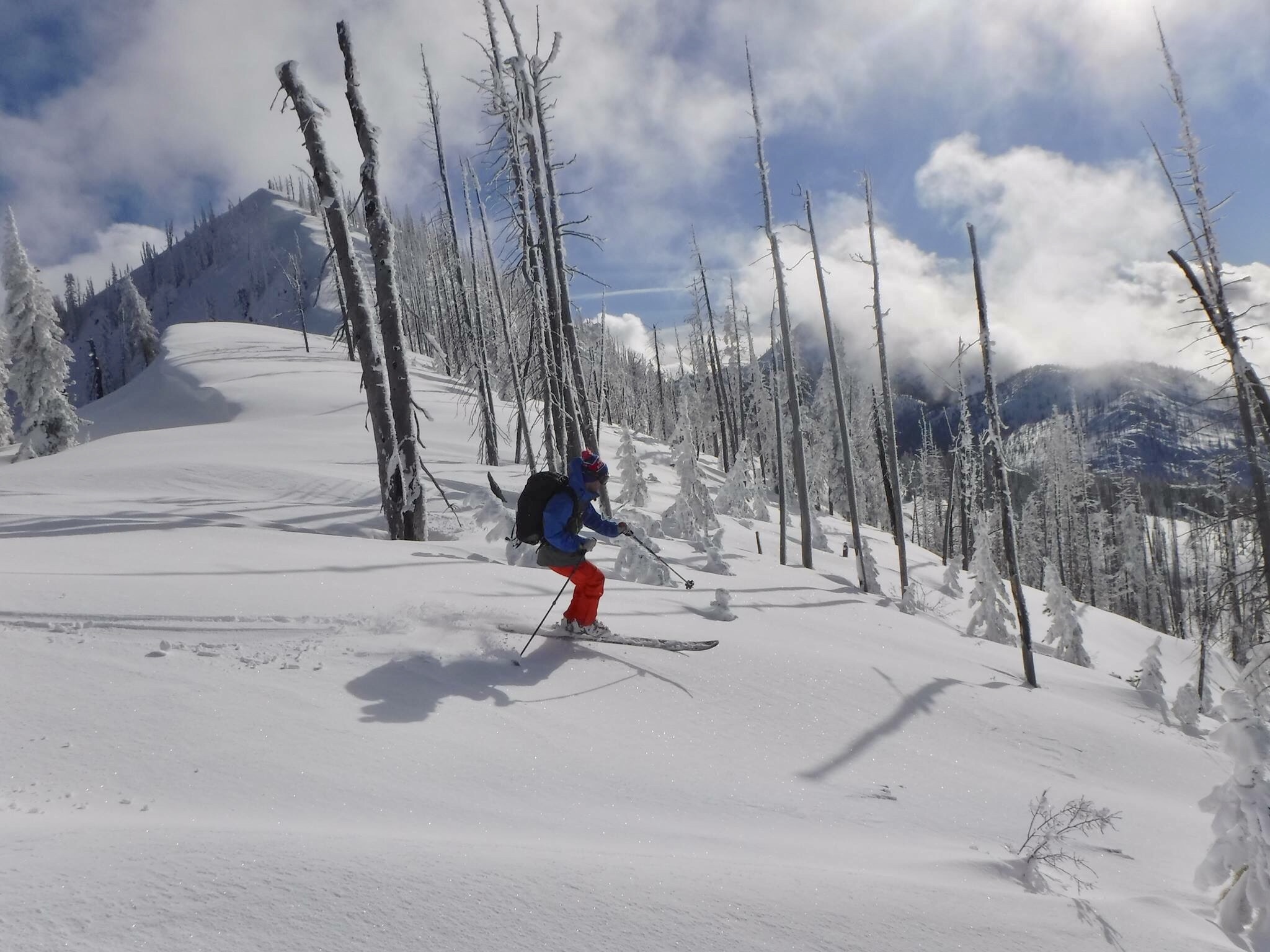
Ski season is just around the corner! Since I am traveling and headed to warm and tropical Thailand next, my season will be a bit delayed this year until I arrive in Hokkaido, Japan in mid-January. Still, November days bring me thoughts of winter and dreams of snow. This post is from an article I wrote for Backcountry Magazine back in 2016. Read the original post here.
One by one, beads of rain race down the window; tear drops reflecting the mood of this gloomy, midwinter day. The final scraps of snow from the last storm cling to the edges of my roof before gravity pulls them to the earth. Individual crystals of snow are swept away by the maddening flow of liquid, while others disintegrate into the soil, lost to the depths of the world. I hunker in my Bend, Oregon home, watching the streets fill with the morning showers. What was once a wintery world washes away like a withering thought. And in all this rain, I dream of powder.
…
I remember a time, not too long ago, when I would dance with the mountain; a rhythmic waltz in which mind, body and snow become one; an experience known only by subject and mountain: the art of skiing. As I stand at my window, rain pattering down outside, I close my eyes, feeling myself slide down the white slope, bouncing in and out of turns, legs springing and compressing into perfect tele position, each pole plant marking the birth of the next turn. The snow is thigh deep, yet I feel no resistance as I swiftly glide through it. Looking downhill, I spot my ski partners reapplying skins to their skis at the bottom of the glade. The warm sunlight transitions to the cool shadows of the looming lodge pole pines. I sense that I am invincible, completely seized by the wonders of gravity. With my companions expanding into my vision, I attempt one last turn, punching downhill with my uphill arm and, the next thing I know, I am flying.
I smash face first into the deep, soft powder. In a jumbled mess of skis, legs and poles, I surface with snow caked onto my face and crammed inside my ears. Smiling and laughing, I fall back and lounge in the powder pool I just created.
…
I startle out of my daydream as the rain intensifies. Powder skiing as I remember it is restricted to this lone image. The winter world that I became accustomed to every year after the last of the November leaves would descend from the trees is absent.
Staring out into the rain, I remember my days as a child, pressing my face against the window, rosy-cheeked and wide-eyed, to watch snow fall from the heavens. Seeing this magical crystallization of water came with a cluster of possibilities: snow days, the nearing of Christmas, the beginning of ski season. Now, I look back on these memories and remember all the enchanting goods that snow brought, and I think to myself, what will my future children see? Will they know the joys of snow as I did, as so many that came before me did? Will they know what it feels like to ski powder, the type that owns no bottom?
I often wonder what will become of skiing. The days when a foot of fresh justified skipping school, the early morning tours where the skintrack was the only sign of civilization and the endless journey of strengthening mind and body that came from climbing mountains and skiing back down.
Is all this only a fleeting memory that will be washed away with the snow, an idea lost to the past and a dream that will be never be realized? What does the future of skiing hold in this time of melt? For thousands of years, it has provided humans with more than just sport: a livelihood, a mode of transportation, a way to gather food when deep snow made it impossible to walk, and a relationship with the mountains that will vanish into deep crevasses.
As rain patters our January roof, I wonder, am I part of the last generation of skiers?
I just finished the Annapurna Circuit and Annapurna Sanctuary treks in the Himalayas of Nepal, hiking it solo and without a guide or porter. While it takes some planning and preparation, both treks can easily be done on one’s own. This post is meant to both be a guide for anyone who is planning, or hoping, to do the trek in the future, as well as documenting my experience and reflections. For a more complete ‘How-to’ guide on the logistics of hiking the Annapurna Circuit, read my Guide to Hiking the Annapurna Circuit Without a Guide or Porter.
The secret of the mountain is that the mountains simply exist, as I do myself: the mountains exist simply, which I do not. The mountains have no “meaning,” they are meaning; the mountains are.
–Peter Matthiessen, The Snow Leopard
Day 1: Kathmandu (elevation: 4,600 ft) to Chamje (4,675 ft)
This was a travel day from Kathmandu to the trail. Just getting to the trail may have been the greatest adventure of the whole trek. In hindsight, I probably should have spent a night or two in Pokhara first before heading to Besisahar (the official start of the trail), but wanted to start hiking immediately and tried to go straight from Kathmandu—my first mistake of the trip.
I took a tourist bus—the more comfortable, slightly more expensive option—headed for Pokhara and was supposed to switch buses in Dumre; the only problem was the driver never told me where Dumre is, and never stopped there, instead blowing right by. By the time I asked, we were already 30 minutes past and I had to catch a local bus headed back the other way. Upon reaching Dumre, the chaos escalated.
A wiry kid of no more than 15, who had been collecting money and tickets from passengers on the local bus I was on, told me he would take me to the right bus for Besisahar and get me a ticket for 400 rupees. I gave him the 400 rupees—my second mistake—and ignorantly followed him onto some other bus. As we were about to depart, two other men grabbed me, telling me it was the wrong bus and to follow them instead. They then had a heated argument with the kid as I was escorted onto yet another bus and told that this was the bus destined for Besisahar. Confused and frustrated, I didn’t know who to believe, but the two men seemed the more trustworthy of the bunch as they were able to return my 400 rupees from the kid. The bus soon took off and I was on my way…somewhere.
The local buses in Nepal are cheap, crowded, sweltering, sweaty, dusty, and deafening—loud Nepalese pop music roars over the static-y speakers and the bus bumps along the uneven, rocky, dirt roads of the country’s mountainous terrain. I was the only foreigner on the bus, that contained more people than available seats, and a goat—yes, a live goat—crudely attached to the back of the bus. Luckily, one man sitting near me spoke limited English and confirmed the bus was indeed on its way to Besisahar.
Finally, I arrived in Besisahar in the late afternoon, hoping things would be easier once I got on the trail. Much of the first couple days of the Circuit are along a dirt jeep road and, if on a tight schedule, one can opt to take a jeep up, instead of walking, in order to cut out a few days. I found a group that was taking a jeep to the village of Chamje and decided to join. The jeep ride cost me 1500 rupees and took us on an extremely dusty, bumpy, flat-out sketchy road before eventually depositing us in Chamje a little after 7pm, well after dark.
Day 2: Chamje (4,675 ft) to Donagyu (7,495 ft); 10.8 miles
For the first day of hiking, this was a long day, climbing nearly 3,000 feet in elevation through a humid, jungly river canyon. I was sweaty, exhausted, and sore in the shoulders and back from carrying my heavy pack all day, but, nonetheless, I ended up making great time, arriving in the village of Donagyu by 3pm. I attribute much of this to Pepe, my Polish hiking partner for the day, who works as a glacier and mountain guide in Iceland and, turns out, hikes at the pace of someone who is a glacier and mountain guide. I struggled to keep up with him most of the day and by the time we arrived in Donagyu, I was so fatigued I had to call it a day, while Pepe had plans to continue on. Crazy cat.
Earlier that morning, before heading out of Chamje, Pepe and I took a ten-minute detour, backtracking on the trail, to an awesome 100+ foot tall, two-leveled, thundering waterfall. If this was preview of what I would see in the upcoming days, I knew I would not be disappointed.
The day’s hike took me up the heavily wooded canyon of the Marsyangdi River. Parts of the trail felt as if I were stepping through a tropical jungle, before the forest opened up, revealing the high canyon walls and dozens of waterfalls spilling down their sides, cooling me off with mist as I passed below.
One of the luxuries of the Annapurna Circuit is that every few miles along the trail is a village with several teahouses to stop for tea or lunch, and lodges to stay in if one decides to call it a day. We stopped in the small village of Khotro for rest and tea, taking a much needed break from the sweltering sun, which was high in the sky at midday. I had planned to do the circuit as cheap as possible and instead of buying lunches, brought along a healthy supply of granola bars and Snickers bars to keep me going throughout the day.
After walking, and consequently sweating, all day long, I was starving by the time I reached Donagyu. The Annapurna Circuit staple food is Dal bhat—a Nepali specialty of steamed rice and lentil soup (Dal) with various sides like potato curry, cooked vegetables, and a crispy tortilla-like flatbread. The best part is you get as many helpings of it as you can possibly eat, which helped my no-lunch-diet as I was able to consume all my calories in Dal bhat each night. (Along the trail, you will inevitably see ‘Dhal Bat Power 24-Hour’ shirts, and may even be inclined to buy one, as the dish really will be your fuel for much of the trek).
Each location also serves a variety of western foods including spaghetti, macaroni, and pizza, as well as American style breakfasts. Other comforts along the trail include outlets to charge electronics (though they are usually always taken at the busy lodges), wifi (though, predictably, it doesn’t always work too well), and (sometimes) hot showers powered by solar or gas (I found that the solar showers are never warm, but the gas ones are reliable more often than not).


Day 3: Donagyu (7,495 ft) to Dukhure Pokari (10,315 ft); 15.5 miles
Today was a long one. I was actually planning on having a short day, hiking 7.5 miles to Chame, but I arrived around noon and still had plenty of energy so I continued on. I met two females—one, about my age, from Paris , and the other a bit older from Spain—and ended up hiking with them for the rest of the day (I would end up spending the next couple days with them, up until Manang).
The landscape really began to change during today’s walk. Donagyu is still in thick, humid jungle, but as I continued gaining elevation, the vegetation gradually shifted to pine forest, similar to what I would find in my native Central Oregon and Idaho. Leaving Donagyu, I got my first good glimpse of the mountains that would surround me for the rest of the trek; Manaslu, at 26,781 feet, the eighth highest peak in the world, towered behind me, and Annapurna II (26,040 feet) lay just ahead, their rocky, barren, snow-capped peaks a stark contrast from the vibrant variety of green below.
The hike started with a very steep climb that carried me to a ridge offering pleasant views of the early-morning cloudless mountains and the canyon below. From there, the walk was much more gradual as we made our way through the Oregon-like pine forests—at times the landscape honestly looked exactly like those of Central Oregon, excluding the Tibetan-style villages and multitude of prayer flags…actually you see quite a few of those in Oregon as well; every so often, I would get a whiff of the sweet scent of ganja, native to this part of the world, and yet another reminder of Oregon.
We walked through several picturesque villages, including Bhratang, which almost looked lost in time compared to the other villages that are catered towards trekkers, full colorful lodges and souvenir shops. Upon entering Bhratang, one passes by sprawling apple orchards, and several small simple homes. The place almost has an old American Wild West feel to it. Then, in stark contrast, at the end of the small village, is a newer large lodge made of pine logs, resembling something you would find in Alaska or Yellowstone. In front of the lodge is a small café selling cappuccinos and fresh coffee, as well as all kinds of apple-based treats such as tea, juice, pie, and muffins.
It was another hour-and-a-half to Dukhure Pokhari, where I was relieved to finally take off my pack and immerse myself in another bottomless meal of Dal bhat.


Day 4: Dukhure Pokhari (10,315 ft) to Ghyaru (12,380 ft) to Manang (11,610 ft); 16+ miles
This was another long day with several thousand feet of elevation gain and loss. From Dukhure Pokhari, it is about two miles to Pisang where we had the option of taking the strenuous and scenic high route from Upper Pisang or the low route along the road through Lower Pisang. Naturally, we chose the more scenic trail, though it was steep, taxing, and very strenuous. After passing through Upper Pisang, we crossed a long bridge over a stream and began climbing, climbing, and climbing—1,200 feet—up a steep switch-backing trail all the way to Ghyaru. This was by far the most strenuous climb of the trek so far, but definitely not the last.
The views we were rewarded with were more than worth it. At the top, entering Ghyaru, was a little tea shop serving hot tea and delicious yak cheese (this wouldn’t be my last encounter with yak cheese), and a viewing platform covered in prayer flags where dozens of trekkers caught their breath and admired a stunning panorama of (from left to right) Annapurna II, IV, III, Gangapurna, and Grand Barrier.
Many trekkers chose to overnight in Ngawal as it is a challenging day to make it to Manang in one day, especially when taking the high route. However, it was still early when we reached Ngawal, so we continued the descent to Manang, where we arrived around 4pm. We learned that 4pm was much too late to arrive in Manang as nearly all trekkers stop for at least one, usually two, nights in Manang for acclimatization. Thus, it gets really busy and can be difficult to find a room. Luckily, since we were a group of three, we were able to find a triple room, but most other lodges we checked were completely full and many other trekkers were less fortunate.
Herds of yak graze and lounge in the fields around Manang and many of the restaurants serve yak cheese, yak burgers, and yak steaks. As I had been consuming nothing but dal bhat and tea the past few days, I was craving some meat. I decided to treat myself after the long day and ordered a yak steak that was dressed in a garlic sauce and served with fries. It reminded me of buffalo meat, more lean and tender than beef. To drink, I had sea buckthorn juice, made from a small orange berry that grows on shrubs in the surrounding hills and said to contain a multitude of nutritional benefits, as well as helping to prevent altitude sickness. No matter the health benefits, it was delicious.

Day 5: Braga (11,020 ft) to Ice Lake (14,763 ft) to Braga (11,020 ft)
It is important to spend a couple days in Manang because in the next few days, one gains a considerable amount of elevation each day as he makes his way towards the pass. In addition, there are several nice day trips that can be taken from Manang. But, since it was so crowded and chaotic there, I decided to head back 30 minutes to Braga, a much smaller and quieter village with a few descent lodges (The New Yak Hotel, where I stayed, had the best shower I would take the entire trek, and also made a mean veggie burger and homemade carrot cake).
Braga is also the starting point for the Ice Lake trail—a challenging hike that gains over 3,500 feet, well above tree line, to a high ridge where two snowmelt lakes sit facing the Annapurnas. The trail first took me through the old village of Braga, where all the homes and buildings are constructed from flat pieces of slate stacked on top of each other. The village rests on a hill and is dominated by a three-story gompa, or monastery, that dates back to the early 16th century.
At the edge of the village, the trail becomes steep, and treacherous at times, as I climbed through a sparse juniper forest, transitioning to woody bushes and shrubs painted with the reds and yellows of fall, until finally passing above tree line, where only a few grasses and shrubs grew amongst the rock. Along the way, several stupas stood, monuments in eternal worship of the surrounding sacred peaks. About two hours in is a small teashop to rest and adjust to the altitude.
It took a little over an hour to reach the lake from the teashop and the view may have been the best I have seen for the entire trek thus far. I could have stayed up there all day admiring the landscape, but the wind was bitter cold and eventually forced me back down.


Day 6: Braga to Gangapurna Lake and Chongkar Viewpoint
To play it safe, I elected to spend another day in Braga to make sure my body was properly acclimatized. Also, I was quite keen for a proper rest day after Ice Lake the day before, and wanted to take advantage of the nice, hot, steamy shower because I knew it would be my last one for a while.
I went on a short, leisurely hike, more of a saunter in comparison to what I’ve been doing so far, to Gangapurna Lake just outside of Manang, and then up another 45 minutes to the Chongkar viewpoint, nestled below the peaks of Annapurna III and Gangapurna. Though short, the hike still gained a considerable amount of elevation, allowing me to further acclimatize, and provided a superb up close view of the Gangapurna glacier, which feeds into the turquoise-green lake below. At the top, I found a quiet, scenic spot on the ridge and enjoyed a lunch of yak cheese and beef jerky with the view.
I met three kids, about my age, from Colorado up there and joined them for the walk down. They were my type of people and we all clicked immediately, making vague plans to meet up the next day in Letdar before I said goodbye and made my way back to Braga.


Day 7: Braga (11,020 ft) to Letdar (13,775 ft); 6.5 miles
This was a short day compared to the rest, but I could begin to feel the effects of the altitude as we arrived in Letdar, at 13,775 feet. Ice Lake broke my personal altitude record two days prior, but essentially each day since Dukhure Pokhari I have been setting new personal records for highest altitudes I’ve spent the night at. While the body will feel the effects of altitude as it climbs higher and higher, AMS (acute mountain sickness) generally occurs when one spends several hours at high altitude; this is why the rule of thumb of mountaineering is to climb high and sleep low.
Just outside of Manang, I caught up with my new Colorado friends I met the day before and spent the rest of the day—and many more days on, and after, the trek—with them. We arrived in Letdar early and spent the rest of the day relaxing in the lodge drinking tea and playing games. While I could tell it was getting harder to breathe while walking at this altitude, I otherwise felt great and had no symptoms of AMS after spending a few hours here [Read about the symptoms of AMS on my Guide to Hiking the Annapurna Circuit Without a Guide or Porter].
Day 8: Letdar (13,775 ft) to Thorong High Camp (15,940 ft) to Thorong Pedi (14,530 ft); 4+ miles
I continued on with Chandler, Kasey, and David—my Colorado friends—up to Thorong Pedi—the night stop before embarking on the trek’s main event: crossing Thorong La pass the following day. The short hike from Letdar took us completely above tree line and through high mountain terrain, across barren, rocky slopes prone to landslides. The vegetation began to grow few and sparse in this harsh landscape; over eight days, I had journeyed from dense subtropical jungles, through river canyons, pine and juniper forests, over shrub and grasslands, and now up into a landscape dominated by rock and ice. One of the allures of the Annapurna Circuit, what makes it one of the most famous and popular treks in the world, is this variety of landscapes and places that the trekker travels through over the course of the trail.
We came across herds of wild blue sheep grazing along the steep mountain slopes. Blue sheep, apparently named for the color of their tongues, are not quite sheep and not quite goat, but similar to each, and are a common prey for the rare and royal snow leopard that also calls these peaks home. Himalayan griffons, masters of the wind and sky, soared high above, their large, outstretched wings (they have wingspans of up to 15 feet!) silhouetted against the bright morning sun as they hovered in the gentle breeze, scanning the ground below for kill. While the Annapurna Circuit, especially in peak season, never really feels like a true wilderness experience, as hundreds of other trekkers are also on the trail and one passes through villages with supplies and modern amenities every few miles or so, in this moment I felt all the wildness, all the untamed majesty of the Himalaya—a place that has drawn adventurers, explorers, and dreamers for years.
We arrived in Thorong Pedi before noon and had all afternoon to relax and prepare for the next day’s expedition. My friends were actually staying in Thorong High Camp that night, about an hour, and almost 1,500 feet, above Thorong Pedi, but it is virtually impossible to find a bed at High Camp during peak season if you do not have a guide (which they had) or book ahead. Since I’m on my own, I had to stay in Thorong Pedi for the night, but accompanied them up to high camp for the day to take in the views and further acclimatize before the big day in the morning.
High Camp essentially consists of just one lodge and its restaurant, but the views of the surrounding mountains are incredible. We walked up a hill of loose slate and rock up to a viewpoint, where, at the top, was a narrow ledge and a jumble of fluttering prayer flags wrapped around a rock pile. As we sat in silence on the windy ledge, I could see far down the valley, all the way to Manang and many of the places I had been the past few days. The only sound was that of the steady wind. The moment was perfect. Time stood still. The mountains gazed from above.
At Thorong Pedi, I ended up seeing many of the people I had met along the way, including Pepe, the Polish glacier guide I hiked with on the first day. Thorong Pedi is one of the places everyone stays at before attempting the pass, and gets packed nearly every night in high season. In the late afternoons, everyone gathers in the dining area, warmed by the fire, trading stories and playing cards until dinner is served. We all went to bed anxious and excited that night.


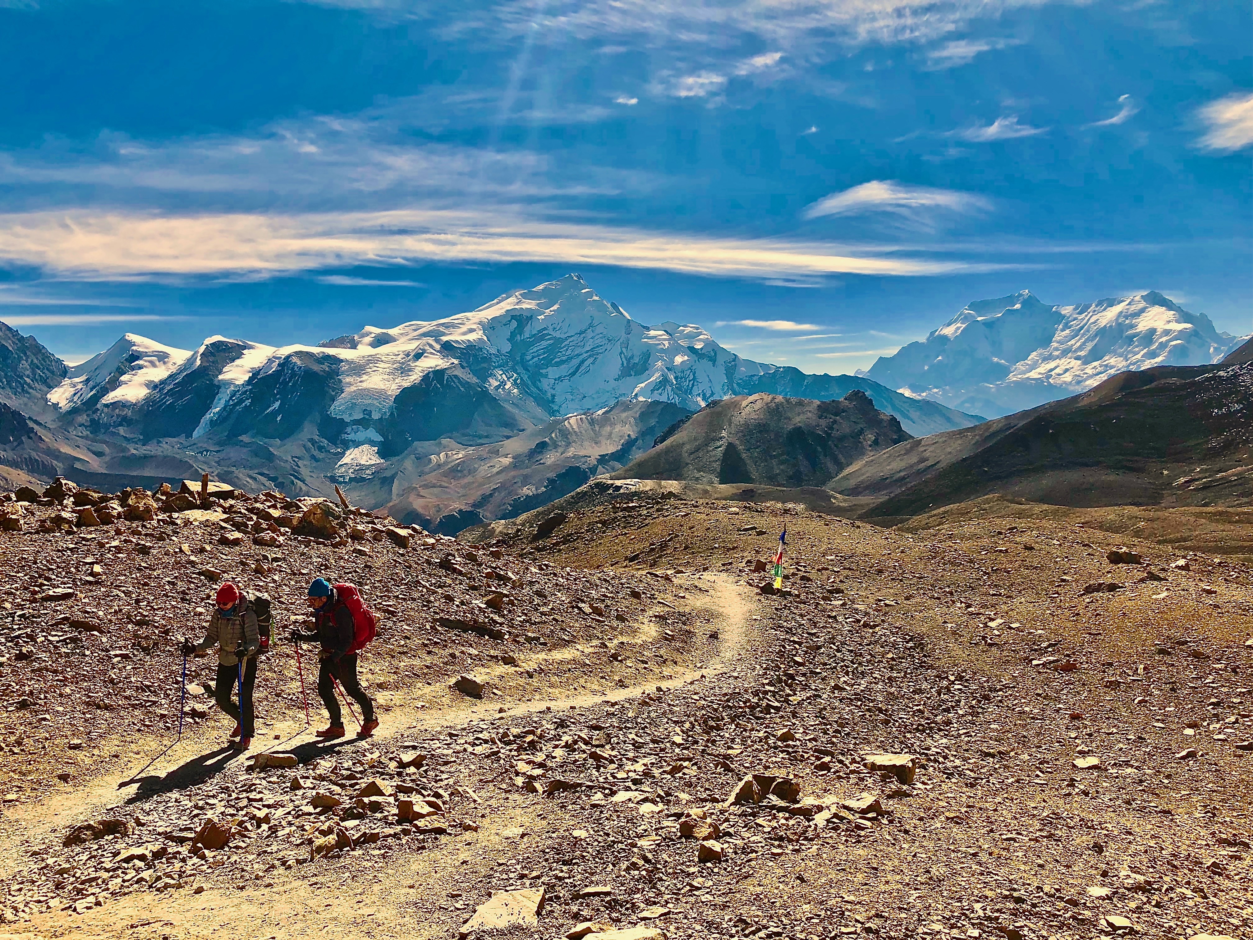
Day 9: Thorong Pedi (14,530 ft) to Thorong La (17,768 ft) to Muktinath (12,140 ft); 9 miles
This was the day, the high point of the trek—both literally and figuratively. The day we had all been thinking of and training for since day one. Today, I crossed Thorong La pass, reaching a dangerously high altitude of 17,768 feet, where the weather can be unpredictable and a fair, sunny day can turn deadly without notice. Some trekkers, mostly those with guides, start the march towards the pass at 4am or earlier. This is because the winds and clouds tend to roll in around 11am and the guides insist on being well off the pass by then, just for precaution. I figured this was unnecessary and slept in, getting a late 5am start.
Well, I wanted to be on the trail by 5am, but things didn’t quite work out that way.
After a cold and restless night at Thorong Pedi, I awoke for the difficult day that lay ahead. I felt as though I was as prepared as I could be, sleeping in, and hiking to, high altitudes the past few days to acclimatize. Though I physically felt great, everything else seemed to go wrong.
First, I tried to wake up by 4am to spend a few minutes shooting the night sky, taking long exposures of the mountains silhouetted against the starry sky above. About ten steps outside my room, my one and only headlight went out. I fumbled around in the dark setting up my tripod and getting the shot ready, but could hardly see anything. The shots didn’t turn out and by the end my hands were frozen and I had to head inside. This ordeal wasted about 20 minutes, and I still didn’t have a working headlight, on the one day I actually needed it. I wondered if these misfortunes were a bad omen warning me I shouldn’t attempt the pass today.
Fortunately, most others were awake by then, also preparing to start hiking, and two girls—one from Oregon, of all places—came to my rescue and loaned me extra batteries. My luck seemed to shift. It was 5:40 by the time I left camp, but I was on the trail, moving quickly to warm my toes, fingers, and face, numbed from the bitter morning chill.
The steepest climb of the day, it took a little over an hour to reach High Camp, and by the time I got there, the sun was up and daylight poured over the mountains. I stopped for a cup of tea to warm up before continuing on. As I prepared to start walking again, I ran into a couple from Barcelona I had met earlier on the trek and walked with them up to the top of the pass.
After High Camp, the trail became much more gradual, but the going was slow as we climbed above 16,000, and then 17,000 feet. The weather was ideal, as there was not a cloud in the sky, and with the winds calm and sun beating down, I removed my wind pants and opened all the vents in my jacket. A little over a mile before the top of the pass we reached a small teashop that also has a few rooms in case of emergency. It’s hard to believe someone stays up here to keep it open.
My body felt strong, and I tried to breathe slowly, only inhaling and exhaling through my nose, but my lungs and legs still strained with each step, slowly moving one foot in front of the other. Every so often, a guide and horse—with a tired trekker on its back, would pass by; many others stood at various spots along the trail, waiting for those who would decide it is too much and opt to pay for a horse to take them over instead. I’ll admit that it was tempting.
At this altitude, we were too high for any vegetation; only ice and rock are found here. I was over 17,000 feet in elevation—well above any peak in the United States outside Alaska—and only a few hundred away from the summit, a summit that never seemed to come. I stopped after every few steps, gasping for breath in this oxygen-starved environment. Looking back, the sun was now high above the mountains, which gleamed brilliant white in the daylight; they seemed to be watching, encouraging me on from above.
The sound of cheering came from ahead. That must be it! Groups of people taking photos and waving flags appeared atop a hill, where I was greeted by a sign enveloped in prayer flags that read “THORANG LA PASS: 5416 mtr. CONGRATULATION FOR THE SUCCESS.”
I had made it. At the summit is another small teashop, providing a well-deserved cup of hot tea. Just behind, is a rocky hill I climbed up to enjoy the view and my accomplishment in solitude. The weather was remarkably beautiful and I ended up spending an hour up there taking it all in and leaving just before noon.


For me, the hike down to Muktinath was the most difficult part of the day, as the trail follows a steep, knee-crunching path over 5,000 feet down to the village. The trail is so steep at times that you can’t help but run down, barely avoiding a slip and tumble. By the time I reached Muktinath, my knees felt as if they were about to give out underneath the weight of my body and pack. I thanked myself for buying poles in Kathmandu before the trek, a necessary item I was originally planning to go without (I found a pair of new, decent poles for about $13).
On the other side of Thorong La, I entered into the Mustang district, where Muktinath is located, and the culture is heavily Tibetan-influenced. I almost felt as if I stepped into a completely new place, as the environment here was dry and the mountains brown, vaguely reminding me of the San Bernardino Mountains of southern California.
In Muktinath, I once again saw many familiar faces from along the way, all successfully crossing the pass as well. It was a night of celebration. I ordered a small bottle of Apple brandy, a local treat made from the apples that grow all over the region. I’m not sure if it was the altitude, or the fact that I was exhausted, dehydrated, undernourished, and hadn’t had a drink in over two weeks—probably a combination of all—but the brandy hit me way harder than I anticipated. Happily wasted, I went to bed and slept better than I had in days.

Day 10: Muktinath to Tatopani (by bus)
Most people either finish trekking in Muktinath, or Jomsom (about 11 miles from Muktinath), or take a bus farther down before resuming. From here, much of the trail follows the jeep road, which gets incredibly windy and dusty. I took a bus to Jomsom for 330 rupees, and then another bus to Tatopani for 800 rupees (if you are in a hurry to leave, you can also fly out of Jomsom, or take the bus all the way to Pokhara or Kathmandu). For those who continued hiking from Jomsom, it looked absolutely miserable. Strong gusts of wind blow up the Kali Gandaki River, and in a naturally sandy environment, coupled with the dirt road, dust flies around everywhere. I mean, the bus sucked too, as we bumped and jolted along the rocky road, dirt also flying in our faces from cracks in the old windows, but at least I wasn’t out there.
The road follows along the muddy, silty Kali Gandaki, and passes through several towns, most much larger than those in the Manang district, on the other side of the pass. I spotted several abandoned mansions, out of place for the area, and Nepal, but remnants of the prosperous Tibetan salt trade, which brought riches to the people of this area who strategically used their geography to benefit from the lucrative trade. Those days are long gone now, these buildings the only reminders of better times.
It took about five hours from Jomsom to reach Tatopani. Tatopani literally translates to “hot water,” as there are hot springs pools along the river. The village is fairly large and has a plethora of accommodation options, including a couple lodges on par with cheap western hotels for 2000 rupees a night. This is a place one could spend two or three days relaxing and recovering from a long trek.

Day 11: Tatopani to Chitre (by jeep) to Ghorepani; 2.2 miles
I woke up early to go soak in the hot springs, before heading off to the next destination, hoping they wouldn’t be too crowded in the morning. Even at 6:30am, they were busy, but still with plenty of room. It costs 100 rupees to enter the pools, and the locals seemed to do their daily bathing there. There are two pools, one lukewarm where many of the women and children bathed, and a decently hot pool that was much less crowded. I chose the hot one, allowing my weary muscles to loosen in the steamy pool as I watched the sun climb into view above the river canyon.
I stayed for about 45 minutes before heading back to the hotel for breakfast. I met a couple from San Diego who had similar plans to head to Ghorepani and continue onto the Annapurna Sanctuary trek from there. We split a jeep as far as we could get, to Chitre, and walked the remaining two miles up to Ghorepani. Ghorepani sits on a hill with a great view of Annapurna I, Annapurna South, Machhapuchhre (Fishtail), and Dhaulagiri, though clouds blanketed all of them by the time I arrived, and is an hour away from the famous viewpoint at Poon Hill.
To my surprise, my Colorado friends showed up at my hotel as I was lounging in the dining area. They were exhausted from a long day as they hiked all the way from Tatopani, which is apparently a treacherous climb and not recommended to do in one day. Nevertheless, we were all reunited again and shared our stories from the last time we saw each other over dinner. We all made a plan to hike up to Poon Hill in the morning for sunrise.
Day 12: Ghorepani (9,020 ft) to Poon Hill to Siprong/ABC Trek (6,400 ft); 14 miles
We started out at a dark, chilly 4:30am. It took a little less than an hour to reach the top, but most of the way was spent in a slow-moving line up the stone steps, as hundreds make the pilgrimage to Poon Hill each morning for sunrise. A train of headlights zigzagged up the hill, illuminating the darkness, ants climbing the mound. Poon Hill is a destination in itself, as it is the end of a short four-day trek from Pokhara, as well as being a fitting end for trekkers on the Annapurna Circuit. It was actually the first time the entire trek I saw Annapurna I.
When we arrived at the top, the darkness was faintly giving way to sapphire across the horizon, and the mountains were still a set of shadowed figures in the distance, cloaked and masking all their splendor and majesty for the appearance of the day’s sun.
I had my reservations about Poon Hill after reading about how crowded it gets, and the fact that I had to wake up at 4am to walk an hour to it, on top of the long hike I already had planned for the day. It turned out to be epic and absolutely worth standing in the cold darkness with hundreds of strangers, as once the sun rose, illuminating the brilliant peaks in rays of red, pink, and yellow, we all admired and applauded these awesome mountains for a final time, and some, like Annapurna I and Annapurna South, for the first time. From left to right, you view a panorama spanning from the Dhaulagiri massif, with Dhaulagiri I—the seventh highest peak in the world at 26,794 feet—towering in the middle, to Nilgiri South, across to the Annapurna range with Annapurna I—the tenth highest peak in the world (26,544 feet), Annapurna South (23,684 feet), Hiunchuli (21,131 feet), and Machhapuchhre (22,955 feet). I could even barely make out Manaslu—the eighth highest peak at 26,781 feet. Thus, from that viewpoint, I could see three of the ten highest mountains in the world. My new friends and I enjoyed the spectacular scene that played out in front of us and then headed back down to Ghorepani for breakfast, content and joyful, before, once again, heading on our separate ways.


Since I had finished the Circuit fairly quickly and had a few days to spare, I decided to add on the Annapurna Sanctuary/Annapurna Base Camp trek, which can be accessed from Ghorepani. I took the path out of town towards Tadapani (not to be confused with Tatopani) and Chomrong, where I would meet the ABC trail. Most people take around 6-8 days to do the trek, but I was hoping to do it in five, which, in hindsight, I would not recommend as they turned out to be very long days and I was wrecked by the end. Instead, I would do four days to ABC, rather than three, and two out, arriving in Pokhara the sixth day. Oh, well…I still made it and had plenty of time to rest and recover in Pokhara afterwards.
From Ghorepani, the path climbed steeply through a rhododendron and birch forest, ascending to another viewpoint equally as scenic as Poon Hill, with a fraction of the people. I’m glad I did Poon Hill as I had good people to enjoy it with, but for those who want to cut out an extra two hours of walking and aren’t keen on the tourist trap that is Poon Hill, this viewpoint provides just as good of a view, and it is already on your way.

The trail then began to descend into another rainforest-like, jungle landscape. Just before entering Tadapani, I glimpsed a small, grey figure scampering across the trail—a monkey! I stopped to see if I can spot it again, and after a few moments of silence, I saw it swinging from tree to tree in the canopy above. Suddenly, treetops began shaking all around and more appeared. I counted seven or eight in total. These were grey langurs, with grey fur, white heads, and dark colored in the face.
Tadapani has several lodges, but gets fairly busy as most people stop here for the night. Up until the village, I passed numerous tour groups and herds of people—the trail being even busier than the Circuit, but as soon as I left the village, I was the only person on the trail until Siprong, save for a few locals going about their daily lives. It was quite eerie at first as the chatter of monkeys, birds, and the sounds of the jungle filled the air around me, and not another human was in sight. For a while, I thought I had taken the wrong trail…
At one point, I actually did get lost, taking the wrong path when the trail forked and walking in the opposite direction for over 20 minutes. It is wise to carry a good map or have GPS here as the trail is not clearly marked in many places. I eventually realized my mistake and backtracked to the right trail, but by the time I arrived, I was spent and ended up stopping at the first lodge I found, which happened to be in Siprong. Gurjung, a much larger village and my original planned destination for the day, was only a little over half a mile away, but involved a steep descent down to the river and then an even steeper ascent up a long flight of stone stairs. It didn’t look enjoyable, so I saved it for the next day.
Day 13: Siprong (6,400 ft) to Himalaya (9,510 ft); 12 miles
This day was hard; maybe the hardest day of the entire trek for me—yes, even harder than crossing Thorong La…maybe. Mileage-wise, it wasn’t too long, just much of the path consisted of stone stairs, climbing and descending, climbing and descending, then climbing some more and descending some more, until my knees and thighs felt as if they were going to give out. It was like doing a stair-stepper for ten hours, with a 30-pound pack on. As I was once again in (relatively) low elevations, the humidity and heat were intense during the daytime, causing me to sweat and pant the whole way up.
In Chomrong, the trail meets up with the main trail to Annapurna Base Camp, which is well marked and even provides an estimated time, in hours, from village to village. Chomrong is a large village and one of the most well-supplied in the entire Annapurna Conservation Area. Almost anything you need can be found here, and if you desperately need something, get it here because it is the last proper village you will come across on the way. Past Chomrong, there are no ‘real’ villages, just clusters of lodges all the way to ABC.
The Annapurna Sanctuary is managed almost similar to a Wilderness Area in the United States, though much less strict in regulation. It is a protected area and has long been considered sacred by local people; thus, there are no jeep roads are large settlements like you would find on the Circuit. In addition, wood fires are banned to prevent deforestation, and plastic water bottles are also banned, so one must either treat his own water, or fill up at “Safe Drinking Water Stations,” located at most lodges, costing anywhere between 60-100 rupees per liter (The Circuit trek also has Safe Drinking Water Stations along the way, though they are less frequent).
The hardest part of the day is right after Chomrong, as the village sits on a steep hill and it is an extremely, unbelievably long descent down an endless flight of stairs, and then an equally long, but more gradual, climb to Sinuwe. Upon reaching Sinuwe, I was overheated and exhausted and had to stop for lunch (at this point, I was running low on snacks and growing hungrier each day, so I started buying lunch. I also brought more cash than I needed and was able to splurge a bit my last few days. I didn’t know exactly where I would stay that night, but just figured I would keep walking until about 4pm or so, or until I couldn’t walk anymore. The villages on the ABC trek are strategically placed about an hour-and-a-half to two-hours away from each other.
I kept going, feeling strong after lunch and tea. The walk becomes much more gentle and gradual after Sinuwe, passing through a dense bamboo forest lined with ferns along the ground floor. Pristine, crystal-clear creeks spilled from all directions, rushing into the mighty Modi Khola thundering in the valley-bottom below, the river canyon the entire ABC trail passes through, up to its source in the mountains of the Sanctuary. I felt as if this was the Shangri La Western romantics have sought out for decades—a lush, mountain utopia where nature reigns supreme and breathes life and immortality into all its inhabitants.
I made great time, eventually passing Bamboo and Dovan. After Dovan, around 2pm, dark, ominous clouds rolled in and it began to sprinkle, but not hard, not even enough to stop and break out the rain jacket. Nonetheless, this was the first time since I started trekking (since I got to Nepal for that matter) that I experienced any sort of precipitation. As it was still early and, somehow, I still had energy, I continued on. The mountain spirits were looking after me that day. Not five minutes after arriving in Himalaya and finding a bed for the night, an intense hailstorm broke out, battering the tin roof of the lodge and blanketing the ground white. I was grateful to have missed it, and prayed it hadn’t snowed too hard at Base Camp, where I was headed in the morning.

Day 14: Himalaya (9,510 ft) to Annapurna Base Camp (13,550 ft); 6+ miles
Today I made it to Annapurna Base Camp, the highlight/destination of the Annapurna Sanctuary/ABC trek. Another reason most people take four days (or more) to reach Base Camp is for acclimatization as, though the Base Camp is over 4,000 feet lower than Thorong La, you gain altitude very quickly and there is still a possibility for altitude sickness. However, as I had just crossed the pass days before, my body was already adjusted and altitude was not an issue; thus, I was able to do it in three, but a tough three days.
There were honestly several moments—mostly while I was climbing stairs all day—where I regretted not just finishing in Ghorepani and heading to Pokhara early to relax, get a massage, have a proper shower, wear clean clothes, eat good food, drink a beer, and get a quality night’s sleep. Instead, I decided to keep walking. But, as I entered into the Sanctuary and got my first glimpse of the amphitheater of snow-clad peaks around me, it all became worth it.
From Himalaya, I continued through a thicket of bamboo forest, ascending rather quickly, until the forest abruptly thinned out, revealing the awesome cliffs of the canyon and the blue-green glacial waters of the Modi Khola. I could see Machhapuchhre peak (also called ‘Fishtail’) ahead, steadily growing as I approached. The impressive display of mountains all became visible at Machhapuchhre Base Camp (MBC), except for Annapurna I, obstructed by a large hill, and hiding just around the corner.
It’s only a little over two miles from MBC to ABC, and an exceptionally beautiful walk, especially in the morning, before the peaks are covered in clouds. Turning the corner, Annapurna I finally came into view, its wide, long massif spanning much of the picture; Annapurna South towered next to it, and Hiunchuli just to the left. I was among the tallest mountains in the world, sacred to those who live there, and majestic to all who visit.
Growing up in the mountains of the Pacific Northwest, I have always been drawn to these massive piles of rock that litter our earth, created by violent geologic forces over thousands, millions, of years. As the tallest of the bunch, the Himalayas have always had their hold on me. It was humbling to be in their presence, and walk in the footsteps of great adventurers and explorers who came before me to climb these awesome peaks.


Day 15: Annapurna Base Camp (13,550 ft) to Chomrong (7,120 ft); 15 miles
Once again, I awoke for the sunrise—I don’t think I’ve ever seen so many sunrises in one week in my entire life, rolling out of my warm sleeping bag into the frosty, bitter darkness outside. At 5am, the stars were still in full effect, illuminating the blackness above the bowl of mountains around Base Camp. It was so cold my fingers went numb within seconds each time I removed my gloves to snap a photo. The night was brutally cold and I was forced to use my sleeping bag, a blanket, and sleep in all my warm clothes. A crazy Japanese guy decided he wanted to camp outside in his tent below the peaks. With nighttime temperatures hovering around 0º F, it’s needless to say it was a little bit samui, but the night sky views were epic. Sometimes the greatest rewards require the greatest suffering.
At around 6am, the first light glowed brilliant red on the tips of Annapurna South and Annapurna I, and soon after, golden light gently poured into the basin, like honey into a bowl. It was a dazzling sight.
I started down the same path all the way back to Chomrong, finishing by climbing the endless staircase I had been dreading since I walked down it two days earlier. Cursing who ever designed the layout of this village, I stumbled into a lodge, barely making it to my room before collapsing. Several servings of dal bhat, some chocolate cake, and masala tea improved my mood and I remembered the grand spectacle I witnessed that morning.

Day 16: Chomrong to Nayapul to (by bus) Pokhara; 11 miles
The last day of the trek! While I enjoyed (nearly) every moment of the trek, and grateful I decided to add on the Sanctuary/ABC at the end, I was relieved to be done walking. Fueled by the eagerness to finish, and high on the elevated oxygen at these lower altitudes, I practically ran down the trail, which, of course, consisted of more stairs for the first part.
I stumbled into Nayapul hot and sweaty, feet blistered, muscles aching, energy drained. It was a long, but not too strenuous, hike down to the town, which marks the starting and ending point of the Sanctuary trek. I could have taken a (relatively) comfortable taxi ride back to Pokhara for 1500-2000 rupees, but opted to torture myself further by taking the cheap (200 rupees) local bus. I ended up standing the entire three-hour ride, where we—I, again being the only foreigner—were all crammed into every available space on the bus. It was like this the entire way along the windy and not-so-paved road to Pokhara. Along the way, the bus blew a tire and we spent half an hour on the side of the road while the driver changed the tire; this was actually a relief as I could get some fresh air. Finally, we rolled into Pokhara by late afternoon and I was officially done.
Conclusion:
I would highly recommend doing both the Circuit and Sanctuary treks, but if I had to choose one I’d do the Circuit. In my opinion, the Sanctuary was actually more scenic and the hiking was better (minus those fucking stairs), as there was no jeep road or vehicles to avoid. The landscape also felt wilder and more pristine, as it is protected from development and pollution. However, the spirit of the Circuit was more enjoyable.
Over 11 days on the Circuit, I walked alone for maybe half a day in total; it was much easier to meet people, and though it was crowded, I found the social aspect a large part of the experience. I walked alone every day on the Sanctuary trail. Granted, I was doing it at a faster pace than most people, trying to finish in five days, but I found the majority of trekkers heading to ABC were in large tour groups and mostly stuck to each other, making it harder to start conversation and develop connections like I had made on the Circuit.
In addition, walking through the villages and witnessing the customs and cultures of daily life in the mountains was fascinating to me. It takes a hardy people to make life work up here. There are also so many side hikes one can do from the main Circuit trail that he could spend weeks on the trail. But, both treks have their allures and you really can’t go wrong with either.
The trek is an experience I will never forget. It challenged me physically and mentally, and I learned a ton about myself and what I am capable of. The landscapes humbled me, the people along the way—locals and fellow trekkers—delighted me, and the spirit of the mountains inspired me.
I grow into these mountains like a moss. I am bewitched. The blinding snow peaks and the clarion air, the sound of earth and heaven in the silence, the requiem birds, the mythic beasts, the flags, great horns, and old carved stones, the silver ice in the black river, the Kang, the Crystal Mountain… I am returned into myself. In another life—this isn’t what I know, but how I feel—these mountains were my home; there is a rising of forgotten knowledge, like a spring from hidden aquifers under the earth. To glimpse one’s own true nature is a kind of homegoing, to a place East of the Sun, West of the Moon—the homegoing that needs no home…
– Peter Matthiessen, The Snow Leopard
Oh, Italy–a land of good drink, even better food, significant history, and charming landscapes and cityscapes. Italy truly offers almost everything one could want in a travel destination. Unfortunately, I was only able to stay a week in the country, and only saw a small fraction of it. This is a place I could spend months traveling and still not see everything. Here are some highlights from my short, but worthwhile stay:
Rome
I was only in Rome three days, and despite being hungover much of the time, was still able to cover some of the main tourist attractions–namely, admiring the impressive architectural feat of the Colosseum, tossing coins in Trevi Fountain, and visiting the world’s smallest sovereign state: Vatican City.
Honestly, the Colosseum isn’t much more fascinating on the inside than it is from the outside (and viewing it from the outside is free), but the history behind the building is interesting to learn as it was the center of entertainment for the ancient city. Gladiator fights, battle reenactments, executions, and plays were just a few of the events held in the Colosseum. What makes the whole experience worth it is the ticket also includes entrance to the Forum, the center of ancient Rome that includes ruins of former government buildings, temples, and gardens. In addition, you can cheat the system and skip the line for the Colosseum tickets (up to two hours in the scorching sun) by buying tickets for both sites at the much shorter line for the Forum (took us about 10 minutes).


The Trevi Fountain is probably the most famous fountain in the world, and you will be able to tell as it is jam-packed with people at all times of the day. While you may have to fight for a good spot next to the water, making a wish and throwing a coin is a must-do ‘when in Rome’ and worth the couple minutes of chaos to check it off your bucket list.


The Vatican is an independent city-state located within the city of Rome and the smallest sovereign state in the world–both by population and area. It is the home of the Roman Catholic Church and ruled by the Pope. Also expect to wait in long, hot lines whilst visiting the Vatican, but the line moves fairly fast and we were in within 30 minutes. The highlight was walking up the steps to the dome at the top of St. Peter’s Basilica, which offers a 360 degree view of the entirety of Rome. Skip the line–and save a few Euros–by opting to walk the whole way up rather than take the elevator, but be ready to get your workout in. Also, it is not for those who get claustrophobic–the final staircase up to the top is in a tight enclosed space that you share with dozens of other sweaty people and no ventilation. However, if you are able to endure a few minutes of sweatiness and lack of oxygen, the views at the top are well worth it.

Sorrento Coast
My last four days in Italy were spent on the southern end of the peninsula in the Sorrento area. Using Sorrento as a home base, I took day trips to Capri, Pompeii, and Positano. While Sorrento is a worthy destination itself, these other locations (in addition to the Amalfi Coast which I didn’t have time to visit) are the real attraction and can be easily accessed from the Sorrento via ferry, train, or bus.
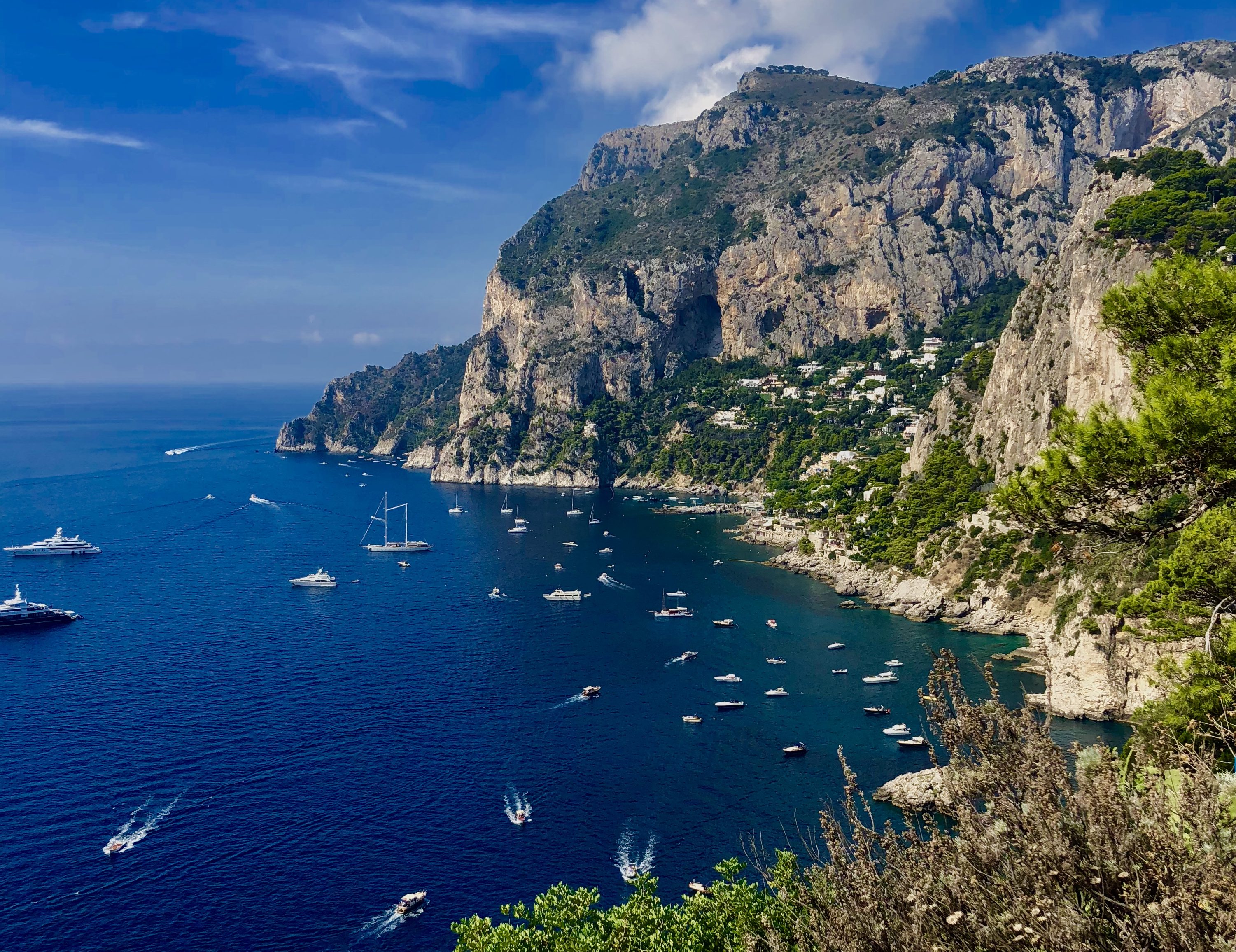
Capri was without a doubt the highlight of my Italy trip. A small island located just off the coast, Capri is just a short 30 minute ferry ride away from Sorrento. The ferry leaves every half an hour or so starting at 8am with the last boat back at 6:30pm. We got to the island around 10am and took the 6:30pm ride back, but if I were to do it again, I would have gotten to Capri even earlier as we easily could have spent another couple hours exploring the island. This was by far my most expensive day as it cost 38 Euro for a roundtrip ferry ticket, and everything on the island is very pricey as it is often frequented by celebrities and wealthy yacht owners, but the experience was well worth the price.
Colorful Italian homes perched along the islands steep hillsides and cliffs overlooked the clear, deep blue Mediterranean below. Fruit trees, grape vines, and vibrant flowers lined the narrow stone alleyways, enhancing the the warm air with a fresh citrus-like scent. In town, Gucci and Versace stores lined the streets, intermixed with seafood restaurants serving fresh catch of the day.

After exploring the town for a bit we took a bus over an incredibly windy and sketchy road built into the cliffside, over to the town of Anacapri on the other side of the island. My friend, and travel partner, Zoe, had heard about a chairlift that you can take to the highpoint of the island from Anacapri. This turned out to be absolutely epic as we rode a small, single-person chairlift that took us high above the island to some truly breathtaking viewpoints.


Instead of taking the lift back down, we decided to walk the steep, but short trail back to Anacapri. To save money, you could hike up to the viewpoint as well, but the chairlift was an enjoyable experience in itself and worth the 8 Euro ticket.
The next day, we took a train from Sorrento for about 3 Euro to Pompeii to explore the famous ruins there. I knew the story of Pompeii–how an eruption of Mt. Vesuvius had buried the city in ash and killed nearly all its inhabitants–but other than that, to be honest, my knowledge of the site was minimal and I didn’t quite know what to expect. While I found the Colosseum to be a bit underwhelming, Pompeii was the exact opposite. I was surprised by how large the city was, as it contained around 11,000 residents at its height, and the ruins are subsequently massive. What makes the ruins so incredible is the fact that the artifacts and buildings were removed from air and moisture since the city was buried under several feet of ash, thus, eliminating natural decay and erosion. As a result, many of the structures and artifacts are well preserved. The murals and paintings on the walls of homes are still vibrantly colored and detailed, as if they were painted a few years ago. Even some of the bodies were preserved, cementing their final moments in time.


Our last day in Italy, we took a cheap (2 Euro) bus ride to Positano, a popular coastal town and beach destination about an hour south of Sorrento along the Amalfi Coast. Positano is one of those postcard destinations characterized by colorful Italian style homes, long beaches, and a gelato stand seemingly around every corner. After several days of intense sight-seeing, and many, many miles walked, we spent the day at Positano relaxing on the beach and swimming in the sea. Swimming in the Mediterranean had always been a bucket list item for me, and one of my main goals while I was in Italy (aside from eating good food and drinking lots of vino, of course). The salt content is so high that I hardly had to use any effort to float. I lied on my back, zero-gravity style, floating at the top of the warm sea, watching clouds roll by for several minutes. It was a splendid week in Italy, a place I intend to visit again in the future, to see other parts of the country I missed this time, but mostly to eat more pasta and pizza.


